Another warm and muggy start to the day has led to strong to severe storms throughout the rest of Saturday. Our weekend is absolutely split, there will be a significant chance in the dry airmass that will take over our Sunday opposed to the hot, humid and stormy Saturday we’re dealing with now.
Click here to see active weather alerts in New England
Tornado warnings that were issued for Plymouth and Bristol counties in southeastern Massachusetts through 9 p.m. Saturday have now expired.
A severe thunderstorm capable of producing a tornado was located over West Bridgewater, or over Bridgewater, at 8:31 p.m., moving east at 45 mph, the National Weather Service said. Radar had indicated rotation.
Get Boston local news, weather forecasts, lifestyle and entertainment stories to your inbox. Sign up for NBC Boston’s newsletters.
This dangerous storm was projected to be near Bridgewater, Middleborough, Pembroke, Rockland, Duxbury, Whitman, Hanover, East Bridgewater, Kingston and Carver around 8:35 p.m., Plymouth around 8:40 p.m. and Marshfield around 8:45 p.m.
Local
In-depth news coverage of the Greater Boston Area.


Tornado warnings that were issued earlier Saturday in northern Connecticut for Windham and Tolland counties until 8:15 p.m. and 7:45 p.m. respectively have also since expired.
Severe thunderstorm warnings were issued for Windham and Tolland counties moments before the tornado warning. A severe thunderstorm warning was later issued for Fairfield County in southern Connecticut until 8:30 p.m.
In Massachusetts, there were severe thunderstorm warnings active for Dukes, Barnstable, Plymouth, and Bristol counties until 9:45 p.m.
There were also severe thunderstorm warnings in effect for Providence, Kent, Washington, Newport, and Bristol counties in Rhode Island through 9:45 p.m., and Washington County until 10:15 p.m.
Additionally, there were several flash flood warnings in effect across New England for much of the evening, including in Massachusetts and New Hampshire.
Only warnings remained in Maine late Saturday night, where there were active flash flood warnings for Cumberland, Sagadahoc and Androscoggin counties until 11:30 p.m.
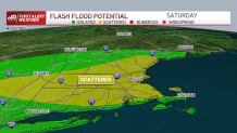
For starters, a heat advisory is in effect from Middlesex county south into Plymouth county and down west to Connecticut as the heat indices will range in the 90s. A flood watch follows with the wake of storms in the middle of the afternoon and evening producing heavy localized rain that may accumulate to over an inch and up to 2 inches within an hour or two.
These areas under the heaviest downpours may experience flash flood warnings due to the rapid water rise and the risk of flooding streets.
The potential for severe storms is mainly after 2-3 pm and into the evening with most storms starting to weaken after sunset while slowly exiting tonight.
Straight-line winds will be a primary concern along with the flooding. Wind may exceed 60 mph in localized areas within the path of the stronger storms causing damage to shingles, trees and weak roofs.
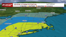
While, lightning will be frequent, some hail may also tag along with the possibility of a tornado or two. Best recommendation is to keep shelter near, as soon as you hear any thunder, go indoors and make sure to stay weather aware.
After this, get ready for a twist in the dew points and a drop in temperatures; we’ll see drier air filling in after the passage of tonight’s cold front which will push out the clouds, increase sunshine and highs in the upper 70s.

These comfortable temperatures will remain with us ranging from the upper 70s to low 80s from early to midweek.
The chance of rain creeps in Monday for northern New England and into parts of northern MA, while dew points mainly stay in the 50s. The chance of rain/storms return Friday-Saturday of next week.