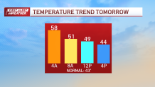
Monday: AM downpours subside for afternoon clearing. Temperatures fall through the 40s. Overnight Tonight: Clear. Lows around 30. Tuesday: Mostly sunny. Highs around 40. Wednesday: Fair and a bit breezy. Highs around 40.
We're waterlogged Monday morning after multiple waves of heavy rain socked the area overnight. Watch for flooded intersections, overflowing streams and standing water on the way to work and school.
The heaviest rain is finally moving offshore and out to the Cape in the next couple of hours. Improvements are on the way later Monday afternoon, and the sun should make an appearance as well.
WATCH ANYTIME FOR FREE
Stream NBC10 Boston news for free, 24/7, wherever you are. |

Temperatures peaked Monday morning, but now are on the way down. This is not a flash freeze situation, just a drop from near 60 back to the 40s.
Get updates on what's happening in Boston to your inbox. Sign up for our News Headlines newsletter.
We will see temperatures drop near or below freezing Monday night, but roads will have a chance to dry out with the wind. Speaking of, it will still be gusty throughout the afternoon as our storm intensifies and pulls away to the northeast.

Expect cooler temps in the 40s in the days ahead with the coldest temperatures falling on Thursday. This is a one-off thing, however. We're already seeing signs that Friday will recover to near 50 in the afternoon. The better news is that we'll be quieter in the days to come, with no storms brewing anytime soon.
Weather
If you're searching for winter cold and snow, you'll have to hop a plane to Siberia. The bitter air has lodged over on that side of the hemisphere for now, with no concrete signs of any outbreaks or intrusion into North America anytime soon.
Have a great week!


