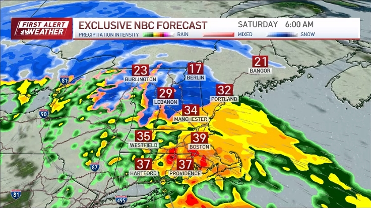
On Sunday, expect a mix of precipitation transitioning to snow by Sunday evening into Monday. In the morning, some areas will experience sprinkles, while Central Mass, north of the Mass Pike, may start with slushy conditions and the possibility of heavy wet snow.
There's a likely break in precipitation during Sunday afternoon, with a resurgence in the evening. Temperatures reach the upper 30s in the afternoon but are anticipated to cool close to the freezing point by the time this second wave reenters.
See all the weather alerts here.

Get Boston local news, weather forecasts, lifestyle and entertainment stories to your inbox. Sign up for NBC Boston’s newsletters.
How cold it is when this second wave comes in will be a key factor, determining whether the precipitation is heavy wet snow(32-34 degrees) or a mix as it reenters most of us getting cold enough by early Monday to see all snow.
Heavy wet snow may lead to issues like weighed down tree limbs and powerlines, posing a risk of isolated power outages. The second round of precipitation on Sunday evening into Monday presents the best chance for snow accumulation.
Follow the storm on our radar:
Snow totals will vary, with the highest expected in Worcester County and southern New Hampshire, likely reaching 5 to 8 inches. Coastal regions, including The Cape, parts of Plymouth County, and Downtown Boston, can expect lower totals ranging from 1 to 3 inches.
Sunday evening's messy travel conditions will persist into Monday morning, but temperatures will rise to the upper 30s by the afternoon. Be cautious, as any remaining water and slush may refreeze early Tuesday when temperatures drop rapidly to the upper teens. Tuesday will remain cold in the mid to upper 20s.

Looking ahead, the rest of the week will bring highs in the upper 30s and low 40s with sunny weather through mid-next week.
Stay tuned and have a great weekend!