Hurricane Nicole made landfall as a category one Hurricane Thursday morning near Vero Beach, Florida, and has begun a slow weakening process now that the storm’s eye is over land.
Power outages and heavy rain will lash central and northern Florida Thursday; eventually, Nicole’s northward motion will accelerate as she feels the influence of a strengthening and deep southwest flow around the jet stream – the fast river of air, high in the sky, that steers storms and is steering a big winter storm through the west-central United States Thursday.
The southwest-to-northeast-oriented jet stream wind ahead of that winter storm will pick up Nicole and carry her north and northeast, over the Appalachian Mountains Friday and into New England Friday night and Saturday morning.
Get Boston local news, weather forecasts, lifestyle and entertainment stories to your inbox. Sign up for NBC Boston’s newsletters.
As Nicole loses tropical characteristics, she will instead resemble a large swath of rain and gusty wind.
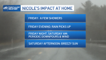
Coming off another beautiful Thursday in New England, with sun and temperatures in the 60s with a southwest breeze gusting to 30 mph, Friday’s clouds ahead of Nicole will mark a noticeable change in the weather, though these clouds should only drop a few, isolated showers for most of the day with a continued southerly wind bumping temperatures to around 70 degrees by afternoon.
Nicole’s rain arrives to southwest New England Friday afternoon, and for more of New England during the late day and evening, continuing overnight Friday night and Saturday morning with embedded downpours at times.
Local
In-depth news coverage of the Greater Boston Area.
Total rainfall amounts of half an inch to an inch of rain in the Boston area won’t be enough for anything more than isolated urban street flooding or pockets of highway hydroplaning, but amounts of 1.5 to 2.5 inches in the North Country may cause some streams to rise above their banks briefly.
As for wind, widespread damage is most certainly not expected, but some isolated damage to weakened trees and particularly limbs is possible predawn Saturday until mid-morning as the south and southwest wind just ahead of the remnant storm center gusts to 40 mph for many and as high as 50 mph near south-facing coasts – sufficient for isolated power outages and to build offshore waves 15 to 25 feet with breakers of six to nine feet at beaches Saturday.

By midday Saturday, the storm center will be racing into central Maine, with rain ending quickly behind it and sun emerging for most Saturday afternoon with mild temperatures around 70! The new, west-northwest wind later Saturday carries in colder air – enough for Sunday to feature highs only in the 40s north and barely into the 50s south, with bubbling clouds producing a few pop-up showers during the afternoon, particularly in the mountains, though we all may see a passing shower.
The new weather theme for next week is: chilly! With passing disturbances raising the chance of showers next Wednesday and again Friday, most days are likely to see high temperatures only in the 40s in our First Alert 10-day forecast.


