
Happy Election Day!
While things are hopping on the election trail, these are the doldrums of autumn, meteorologically speaking.
Leaves are dropping (still some GREAT color to be found around southern New England), the pattern is quiet, the temperatures aren’t too cold (or warm), and the days are super short. And about to get shorter.
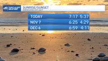
While the debate rages over whether to abolish Standard Time and adopt Daylight Saving Time year ‘round, we’re committed to it this year. And while many would opt to trade the daylight in the morning for some added evening light, the 4 p.m. (ish) sunsets are a mere five days away.
Get Boston local news, weather forecasts, lifestyle and entertainment stories to your inbox. Sign up for NBC Boston’s newsletters.
At least the weather is mellow. Sunshine is limited today with and advancing cold front. That in and of itself will temper the temperatures. The colder airmass in the coming days will do the rest.
Highs fall from the mid-50s today to the low 50s (perhaps only 48/49 in Worcester) tomorrow. The sun is as feeble as a flashlight these days, but it will slowly warm this cold airmass as it crosses over the Great Lakes (warm lake water helps too). The end result is that we should hover near 50 on our coldest days Thursday and Friday.
Weather Stories


Morning freezes are on tap in the suburbs too. Expect the growing season to come to a screeching halt by Thursday morning. We might even get close to freezing on Friday morning in Worcester too. Boston should hover just above freezing right through this cold snap.
Stay warm and enjoy the quiet stretch.
