Today: Mostly sunny with a bit of a breeze. High around 50. Monday: Sunny and cool. High around 40.
The weather in New England takes a turn as drier air moves in following the passage of a cold front Saturday. Mostly clear skies last night allowed the temperatures to drop into the 30s.
Expect a bright and breezy Sunday, although the tail end of an upper-level storm system may bring a few extra clouds and isolated showers to parts of northern and central New England. Highs will be in the upper 40s and low 50s. Monday and Tuesday maintain this calm weather pattern but high temperatures dip to the low 40s.
WATCH ANYTIME FOR FREE
Stream NBC10 Boston news for free, 24/7, wherever you are. |
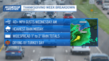
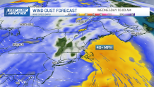
As Tuesday progresses, expect an uptick in cloud cover. Looking ahead to Wednesday, the major travel day, a wet scenario is likely for the Boston metro area and a significant portion of New England. Brace for slower traffic and potential congestion if you're traveling to your holiday destination on Wednesday.
Get updates on what's happening in Boston to your inbox. Sign up for our News Headlines newsletter.
Rain totals currently look to fall near 1” of rain. Frankly, we need the rain, November is behind schedule. The normal month to date rain totals is close to 2” and so far, the Boston airport has only picked up less than 0.25” of rain this month.
Thanksgiving Day itself is forecasted to remain dry with a mostly sunny to partly cloudy sky. The temperatures will lean towards the cooler side, hovering in the 40s. This trend of cooler temperatures in the 40s is anticipated to persist through the upcoming weekend.