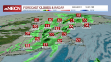
The wind continues to ramp up across the region and will gust at times from 40 to 50 mph (isolated gusts to 60 mph on Cape Cod) through the evening. This will result in pockets of scattered outages and damage.
You’ll still hear it howling Monday night too, only slowly subsiding to the 30 to 40 mph then the 25 to 35 mph range by the morning.
WATCH ANYTIME FOR FREE
Stream NBC10 Boston news for free, 24/7, wherever you are. |
The wind will be accompanied by a band of rain too, with some embedded downpours from west to east between 4 and 10 p.m. After midnight, skies will clear and the temperatures will drop into the 30s.
A few icy patches will be possible in far western and northern New England in the morning, so use caution. Tuesday brings a noticeable change; no more 50s and 60s, but rather highs in the 30s and 40s from north to south with wind chill values about 5 to 10 degrees colder.
Get updates on what's happening in Boston to your inbox. Sign up for our News Headlines newsletter.

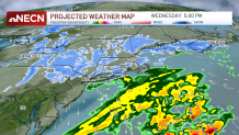
Wednesday’s highs don’t get out of the 30s, which sets us up for snow as the next round of precipitation comes in. The center of the storm will stay out over the ocean, along with the heaviest moisture. There is enough upper level energy over us to trigger snow showers and burst of snow Wednesday late morning to midday, transitioning to some steadier action by Wednesday evening and night.
Right now, the event still looks like a widespread coating to 2 inches. There may be a few locally higher amounts from interior southeast Massachusetts to far southeast Maine -- on the order of 3 to 5 inches if everything comes together just right -- so stay tuned for updates.

It looks like the Wednesday evening commute will have the highest impact. Another quick hitting disturbance slides through on Friday, bringing with it a brief burst of snow to wintry mix then rain for a few hours, which could slow down the morning commute but be gone by early afternoon.
Weather Stories
The weekend features a warm up, with highs in the 50s and some rain drops to dodge, and the start of next week looks quiet and seasonable in our exclusive 10-day forecast.


