
The week’s big weather event is here. Wind and rain descend on New England as a strong cold front arrives Thursday night. But this is not a classic autumn front in the sense that it will deliver much colder air. The air remains virtually unchanged after it passes, meaning we hold on to the mild temperatures right into the weekend.
First up, the timing. A few light sprinkles or quick-moving showers are in order for much of the day. Nothing drenching, nothing serious, until we get to the evening. It’s then that heavier rain could intrude – essentially any time after 3/4 p.m. Later into the night, the downpours will be more furious, with a possibility of a few thunderstorms after midnight.
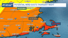
Gusty winds from the south/southeast will top out at 30 to 35 mph for most, but on the Cape and Islands, our winds could be as high as 40 to 45 mph as the front closes in overnight. With this being our first wind event of the season AND fully-leafed trees swaying overhead, there may be some large branches dropping on lawns and streets, along with a risk of brief power outages. The one good thing about this event is that once the downpours scoot out EARLY Friday morning, the wind will come to a screeching halt.
Get Boston local news, weather forecasts, lifestyle and entertainment stories to your inbox. Sign up for NBC Boston’s newsletters.
All told, we’re seeing at least an inch of water, with some spots topping two inches. With thunder as the wild card, we could even cozy up to three in select spots. This is a huge drought-denting rain.
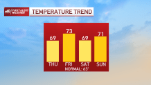
With the skies breaking Friday afternoon, we will see the temps shoot back up into the mid-70s in spots (!!!). The weekend sees a slight dip back to around 70 with sun limited by clouds at times – especially Sunday.
Weather Stories


Updates through the day on the storm.
