We are on a tear with records and heat across New England. While this appears to be the final stand of oppressive heat and humidity, it goes out with a bang – literally.
Once again records are in jeopardy today. The high temperature to beat in Boston is 95 and in Worcester it’s 92. We should at least reach the Worcester record, and likely smash the Boston record. Our forecast highs are 92 and 97, respectively.
WATCH ANYTIME FOR FREE
Stream NBC10 Boston news for free, 24/7, wherever you are. |

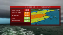
With an approaching cool front by afternoon, our focus will shift from the heat to the brewing storms. In fact, plenty of jet stream energy will combine with high humidity and hot temps to make a prime severe weather day.
Get updates on what's happening in Boston to your inbox. Sign up for our News Headlines newsletter.
Keep your eyes peeled for a line of storms approaching from the west anytime after 3 p.m. and continuing through at least 8 p.m. Primary threats will be heavy rain, intense lightning, damaging wind gusts (including the threat for microbursts), and a low possibility of a tornado.
We don’t take those threats lightly (obviously), and neither should you. Stay safe and weather aware this afternoon!

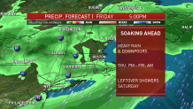
Once the front passes, the cool down will be underway. Thursday’s highs slump back to the low 80s as the humidity continues to lower. Afternoon showers will break out ahead of a wave of low pressure rippling along our front. This mini storm system will be LOADED with water too.
We expect heavy rain to break out Thursday night and carry through at least Friday morning. Some spots could come away with at least 2-3 inches from this round of rain alone.

Now, what to do about the weekend? After the heavy rain threat passes Friday night, we could still see a few lightweight showers drifting around on Saturday. We definitely see the temperatures falling back to the 60s and staying there both Friday & Saturday.
The Independence Day forecast has been slowly improving as each new dataset comes in. We could start a little gray, then develop sun through the afternoon. Although winds will stay from the onshore direction, 70s are still in play (perhaps upper 60s at the coast). It's the best we can hope for in this dreary pattern, which is reminiscent of Memorial Day Weekend.
Stay cool!


