
High pressure will build into the region tonight and provide the area with cold temperatures and clear skies.
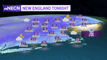
The only exception will be far northern Maine where we’ll see a few leftover snow showers through late tonight with light accumulations. With all the rain we saw in the past 24 hours, as well as the frozen precipitation, it is very likely we will see some black ice developing on the untreated surfaces overnight into Wednesday morning, please be careful. Lows dip into the teens north, low to mid-20s.
Sunshine for Wednesday
Get Boston local news, weather forecasts, lifestyle and entertainment stories to your inbox. Sign up for NBC Boston’s newsletters.
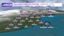
The sun will be back tomorrow along with temperatures across much of the region rising above freezing, the exception will be far northernmost New England. It’s looking like a perfect day to cash in on all the new snow on the slopes! Highs reach the upper 30s to low 40s south, mid to upper 30s. north.
More Rain and Snow Showers Thursday
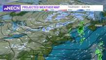
The rest of the week is looking mostly quiet with a weak system moving through during the day Thursday with some scattered rain showers south, snow/rain showers north. Quiet and cool Friday, but what really stands out on our Exclusive 10-Day forecast is the 50 spot on Saturday!
