High temps and popup storms are the focus Tuesday evening as we mark the start of a potential heat wave for most of New England.
WATCH ANYTIME FOR FREE
Stream NBC10 Boston news for free, 24/7, wherever you are. |
We have less humid air today, but the heat is on. As our wind swaps direction and becomes strong from the west, we get a down sloping wind that actually warms as it sinks and so in Boston we will see highs in the low 90s. And not expecting sea breezes today. An isolated pop up thunderstorm is likely across northern New England, with an isolated damaging wind threat.
The city of Boston has declared a heat emergency for Tuesday through Thursday.
Get updates on what's happening in Boston to your inbox. Sign up for our News Headlines newsletter.
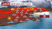
More highs in the 90s are forecast through the week with more humid air, especially Thursday. Heat index values may be in the 100-105 range Thursday so we have another First Alert for all. Overnight lows don’t bring any relief in this stretch of heat. Lows drop to the 70s for most and the humid air will be very uncomfortable for sleeping if you don’t have AC.
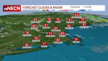
The air is very hot at the ground level, but cooler aloft so this means unstable air can bring us some storms from time to time. Each day pop up isolated strong storms are possible in the heat of the afternoon. More widespread storms and showers roll in Thursday with an area of low pressure passing to our north, and even another severe storm risk is anticipated.
Temps stay hot through the weekend and beyond, “cooling” to the 80s for the rest of our 10-day forecast.