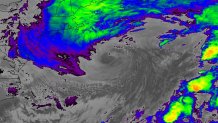
We haven't had many opportunities to marvel at Mother Nature this winter. Other than outrageous warm spells, this season has been lackluster in terms of storms. Last night finally afforded us the opportunity to witness winter in action as a monster storm rapidly intensified (the bombogenesis part) offshore.

Note the grayish "eye" feature in the center of the storm. These share some common traits of hurricanes, so it wasn't much of a surprise when it formed near midnight.
As it pulls away this morning, the snow bands will slowly diminish (always a painstakingly slow process with nor'easters) on Cape as the winds gradually ramp down. Expect gusts to continue in the 40-50 miles per hour range early this morning, then taper to 30-40 later in the afternoon on the Cape and Islands. Sun will rapidly work in from the north to south across the Commonwealth, although total clearing may take until later in the afternoon on the Outer Cape.
With a storm of this magnitude, tides will run above normal with some splashover at high tide this morning. Wave heights offshore match the girth of the storm - some have climbed up to 20-plus feet!
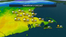
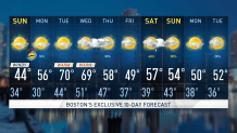
Onward and upward with the weekend. Sunday gets back to the mellow weather as the winds ease and the temps warm back into the 50s.

We're not stopping there, however. A surge of very warm air has been traveling across the country. We're expecting to get caught up in it for a two-day stretch this Monday and Tuesday. Temps will be outrageously warm for early March - easily climbing at or near 70!

A bit of winter and summer in a matter of days. That's spring for you.
Weather Stories
Enjoy your weekend.


