
Today: Fair sky, fall air. Isolated midday sprinkle. Highs around 60. Overnight Tonight: Not as cool, mostly clear. Lows in the 40s. Wednesday: Milder, sun to clouds. Highs around 70. Thursday: Mild and bright. Highs in the 70s.
Chilly start this Tuesday morning, but it's our only cold one this week. In classic New England fashion, we'll go from car (and home?) heaters on high to windows down/air conditioning on late this week — and even part of the weekend.
Yeah, that last part is hard to believe.
WATCH ANYTIME FOR FREE
Stream NBC10 Boston news for free, 24/7, wherever you are. |
Tuesday's temperatures will be about the same as Monday. Low 60s with a blend of sun and clouds. About identical sun/cloud coverage Wednesday, but the airmass will be totally switched out, allowing us to surge to the low 70s in most spots (cooler on the Cape/Islands).

Get updates on what's happening in Boston to your inbox. Sign up for our News Headlines newsletter.
In these autumn (and often spring) warmups, it's the duration of the warm air that nudges the temperatures up. It's nearly impossible with the low sun angle (unless you have a vigorous weather system rolling through) to bounce your temperatures to warm, summery levels in just one day.
Sustained, incremental mild days (and mild nights) can get you close to 80 if the pattern supports it. And that's exactly what we're seeing in the next few days.
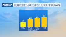
Guidance would suggest we stay in the low 70s, but we compensate for their biases outside of the warm season (less now than in past decades) by pushing the numbers into the upper 70s late in the week. Some spots may even touch 80!
Weather Stories

Enjoy the warmup, it should crumble by the end of the weekend and early especially by Halloween.