
We're enjoying both sunshine and the first day of a warmup. Southwest breezes will scour out the last bits of cold air Thursday morning, bouncing our temperatures back to the upper 40s this afternoon.
This is one of two days that will feature above normal temperatures.
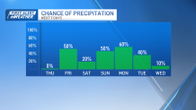
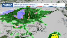
Friday we'll hold back much of the rain until late afternoon. The chances of a steady rain during the daylight hours are pretty slim, and all told, this isn't a soaking rain event in general.
Get Boston local news, weather forecasts, lifestyle and entertainment stories to your inbox. Sign up for NBC Boston’s newsletters.
Leftover clouds will linger into Saturday, but we could see a few rays from time to time. Temperatures will slide back to the 40s, nonetheless.
Things get a little more interesting Sunday into Monday. A larger storm system will approach, spreading steady rain across the area. We'll see this continue into Monday, but colder air will also be sinking down from the north.
The big question is how much cold will get into southern New England before the storm moves out. Guidance is more confident in some flakes making it throughout the Worcester Hills late Monday and Monday night, but it's still a strange setup.
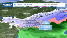
With leftover energy in the upper atmosphere, some of the guidance shows the snow lingering into Tuesday morning (albeit very light). Either way you slice it, this one bears watching as we go into the weekend.
For aurora fans (and who doesn't love the Northern Lights?), a strong solar storm will arrive to earth very late Thursday night. With enough of a break in the clouds, it's possible we could see it this far south.
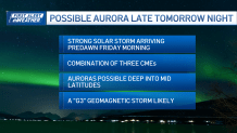
Right now, it appears this will be a moderate/low end major solar storm. Fingers crossed for a show!
