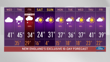
Today has overall been a milder day, we’re enjoying temperatures rising to the upper 30s and some areas watching the low 40s as a treat after a cold stretch.
Mild Temps and Rain Help With Melting Snow
Now much of the snow we see on the yards, parking lots and side roads will continue to melt. But as this snow works on melting today, a storm system is planning to bring some important changes to our region.
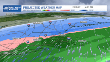
Rain is filling in over much of New England tomorrow, bringing showers for some in the north and western New England by the morning and marching south through the afternoon. The far northern country will see some snow by tomorrow afternoon with the snowline beginning to push south through the overnight hours into Friday morning.
Get Boston local news, weather forecasts, lifestyle and entertainment stories to your inbox. Sign up for NBC Boston’s newsletters.
First Alert for a Wintry Mix Friday
This is when the morning commute gets tricky as we’ll be watching a wintry mix of snow, sleet, freezing rain and snow. Much of the south will remain with rain until late afternoon Friday and Friday evening when the system begins to weaken and push out, but might barely make it to precipitate some snow into portions of the south.
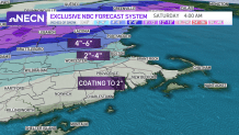
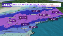
Our total snowfall amounts vary greatly from the southern states to what the mountains might get. We’ll likely remain with a coating to an inch or two in Connecticut, Rhode Island and southeastern Massachusetts. Most of Massachusetts may bump into the 2-4” range but the mountains in Vermont, New Hampshire and Maine could be watching an 8-12” snow range and isolated spots might get lucky enough to get a bit more than that.
We’ll keep a First Alert Stamp in our Exclusive 10-day forecast for Friday, considering our rough morning commute and travel hazards. This weekend will remain dry and cool with below-average temperatures. While next week is coming off with highs in the low 40s by the end of next week.