After a gloomy Wednesday, Thursday is expected to be a beautiful fall day, with mostly sunny skies. Morning lows will mostly be in the 40s, and there is a chance of patchy fog.
High pressure will build east by Thursday afternoon, bringing winds from the southwest. This high-pressure system will result in slightly warmer-than-normal temperatures in the mid to upper 60s, making it an ideal day to enjoy the fall weather.

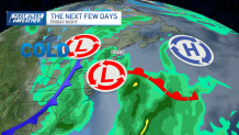
However, changes are coming by the weekend. Rain will begin in spots on Friday morning and increase in coverage for the second half of Friday and into Saturday. Rain chances at this time favor Saturday. There will be some leftover rain showers on Sunday, the scattered showers will begin to taper off as the system exits.
Get Boston local news, weather forecasts, lifestyle and entertainment stories to your inbox. Sign up for NBC Boston’s newsletters.
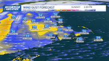
Gusty winds are expected on Sunday and Monday, with gusts as high as 30-40 knots over the Cape and islands and 25 to 35 knots inland. The exact wind speeds will depend on the system's track and timing. Following the exit of the low system, New England will experience mid-level ridging and building high pressure, leading to subsidence and dry weather. However, this will bring cooler northwest winds, which may result in frost on Monday night into Tuesday.

Be prepared for your day and week ahead. Sign up for our weather newsletter.

