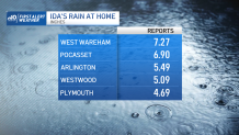
The remnant of once-Hurricane Ida brought torrential rain to southern New England overnight.
The storm prompted multiple motor vehicle rescues and delayed school openings due to flooded roadways and streets. A wide swath of 3 to 4” of rain, with localized amounts of 5 to 6+”, fell across the region.
Four tornado warnings were also issued between midnight and 2 a.m. for Cape Cod and the Islands. There have been no confirmed touchdowns by the National Weather Service thus far.
Get Boston local news, weather forecasts, lifestyle and entertainment stories to your inbox. Sign up for NBC Boston’s newsletters.
The weather will improve today throughout the afternoon and evening. Dry and breezy conditions prevail as the low pressure exists New England. Rain will linger across eastern Maine throughout the afternoon and evening.
High temperatures are in the upper 60s to low 70s with much lower dew points as high pressure noses into the region. This same high pressure takes control of our weather Friday and Saturday. We're expecting sunny skies and pleasant temperatures in the 70s both days – a brief early-Fall preview.
Sunday through Monday, a southwest flow will increase across New England as high pressure slides offshore to our east. This will result in the return of warmer and more humid weather into early next week.
A disturbance may trigger some showers on Sunday with additional chances for precipitation on Labor Day as a cold front treks across the area. High pressure moves back in for Tuesday, bringing drier and seasonably-warm weather in its wake.
Heading into the middle of next week, a dry stretch looks to settle in on the exclusive First Alert Weather 10-Day Forecast on NBC10 Boston and NECN.