Storms produced some severe thunderstorm warnings, but fortunately we are out of the high risk of severe weather for Friday night -- except in parts of western Maine, where a flash flood warning was in place until 10 p.m.
While it was a warm and humid day, drier air will start to fill in Friday night, mainly in the north and the west.
But the chance for showers doesn’t end just yet. We’ll continue to watch for overnight cells incoming from the south and into the northeast, producing intermittent activity.
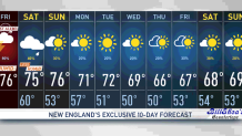
By Saturday morning, we could still see some lingering showers in eastern New England, while the west will enjoy dry weather and clearing in the sky. Most of these showers will be out by Saturday morning before 7, and then it will be a mostly dry day with the rain chances retuning Saturday evening and lasting until the overnight hours of Saturday night into Sunday.
Get Boston local news, weather forecasts, lifestyle and entertainment stories to your inbox. Sign up for NBC Boston’s newsletters.
For Sunday, it’s a split forecast, as northern New England could see the backside of the front producing some additional and light showers, while most of the south will enjoy a dry day with comfortable dew points and highs in the 70s.
Starting next week, we’ll dry out thanks to a high pressure system Monday and Tuesday. It will be until midweek that we’ll see another system bringing in showers and dropping temperatures into the 60s.
Enjoy the split weekend forecast and make the best of it!