The front that caused the historic flooding of the last few days is now moving out of New England. But the upper level low trails behind generating another day with scattered showers and downpours.
With the front going offshore we are losing most of the surface convergence. But there’s still plenty of instability and moisture so a few of us may see another half inch of rain in isolated cases today.
Unlike yesterday, when we had another round of flash flooding up the pioneer valley of Massachusetts into southwestern New Hampshire, causing more water damage. And even an EF0 tornado in Somers, Connecticut, without any thunder!
Get Boston local news, weather forecasts, lifestyle and entertainment stories to your inbox. Sign up for NBC Boston’s newsletters.
The 75-80 mph wind with the tornado pretty much came out of nowhere at 6:15 with no warning, a couple of cars were destroyed by trees, and minor building damage, but no injuries were reported.
July rainfall in Worcester has now passed 12.6 inches, a new record for the month of July, beating the old record of 11.24 inches in 1938.
This is a bit of an ominous sign, as two months later the hurricane of 1938 came up the coast. That doesn’t mean it’s going to happen this year, but there is some correlation between record wet July and further tropical trouble down the road.
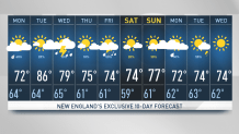
It’s not a washout today but the scattered showers could cause some delays, and no help to the river to continue out of their banks. Temperatures today are mostly in the 70s with lower humidity than yesterday. We should really clear it out tonight, though the ground is so wet, we'll probably have patchy dense fog with a low in the 60s.
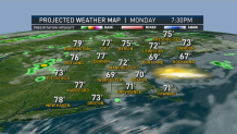
Tomorrow looks nice, at least for the first part of the day, with sunshine for a while and the temperatures getting well into the 80s. The problem is another front is moving in very quickly from southeastern Canada will generate some showers and a thunderstorm.
Weather Stories


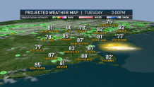
That front may still be here Wednesday, with more showers and thunderstorms. Thursday is probably the next mostly dry day, a lot like last week. And there is some hope for the weekend, that the front may stay off shore at least for most of Saturday.
Stay tuned to our First Alert 10-day forecast for the latest in this volatile weather pattern.