
Sunday morning marked Boston's first freeze of the season, with temperatures dropping to 31 degrees in the city and reaching the low and middle 20s in surrounding areas.
This aligns closely with the typical timeframe for the first freeze, falling within a week of the average first freeze for Boston -- Nov. 5.
Anticipate another chilly one Monday, as the week kicks off with temperatures in the 20s across the board. Monday's highs are expected to reach the mid-40s, but this trend will not persist throughout the rest of the week. Clouds build for the second half of Monday as low pressure moves over northern New England.

Get Boston local news, weather forecasts, lifestyle and entertainment stories to your inbox. Sign up for NBC Boston’s newsletters.
A better chance for rain and wintry precipitation in northern New England, but there could be a quick-moving light shower for the greater Boston area Monday night into early Tuesday.
Tuesday, a breeze will kick up out of the northwest with 10-20 miles per hour winds and mostly sunny conditions return, especially by the afternoon.
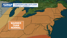
Moving towards Thursday and Friday, expect a noticeable rise in temperatures, reaching the upper 50s and low 60s.
Toward the end of the week and the beginning of the weekend, some rain chances come into the picture.
Local
In-depth news coverage of the Greater Boston Area.

The normal high for this time of year is 52, and by Sunday and Monday of next week, we are likely to settle into temperatures consistent with this "normal," featuring lows in the mid to upper 30s and highs in the low to mid-50s.
