
-
Forecast: Coastal snow possible Tuesday night
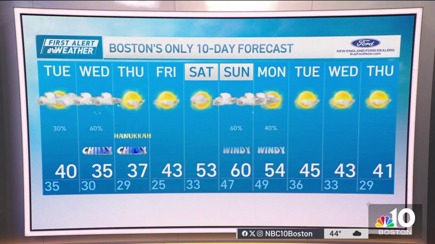
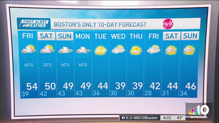
Overnight tonight: Chance sprinkle then partial clearing. Lows in the 30s, 20s north with slick spots.
Tuesday: Cooler, more clouds than sun, sprinkle/flurry possible. Highs around 40.
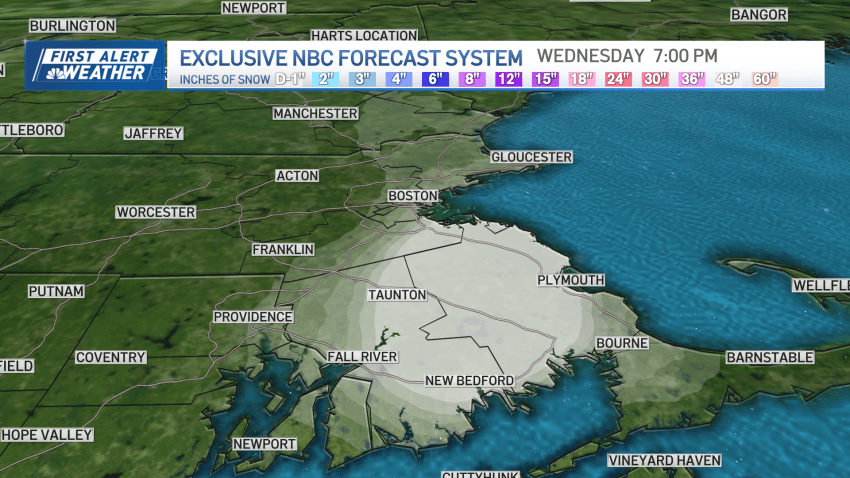
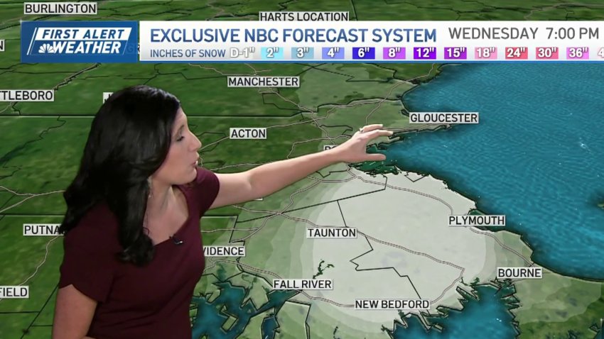
Wednesday: Light snow/rain showers east with a light snow accumulation of a coating to 1″ for some. Highs in the 30s. -
Forecast: Colder days ahead, with a wintry mix possible midweek
Overnight Monday night: Chance sprinkle then partial clearing. Lows in the 30s, 20s north with slick spots. Tuesday: Cooler, more clouds than sun, sprinkle/flurry possible. Highs around 40. Wednesday: Light snow/rain showers east with a light snow accumulation of a coating to 1″ for some. Highs in the 30s.
-
Tuesday will be cooler, with more clouds than sun; Snow possible Wednesday?
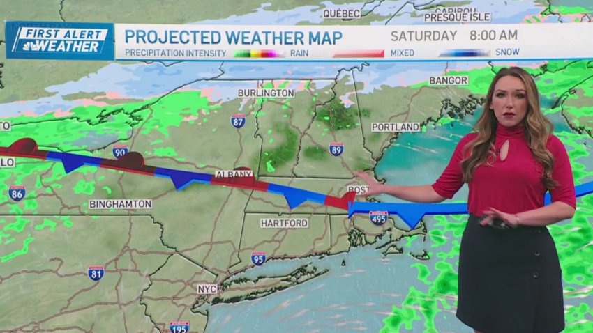
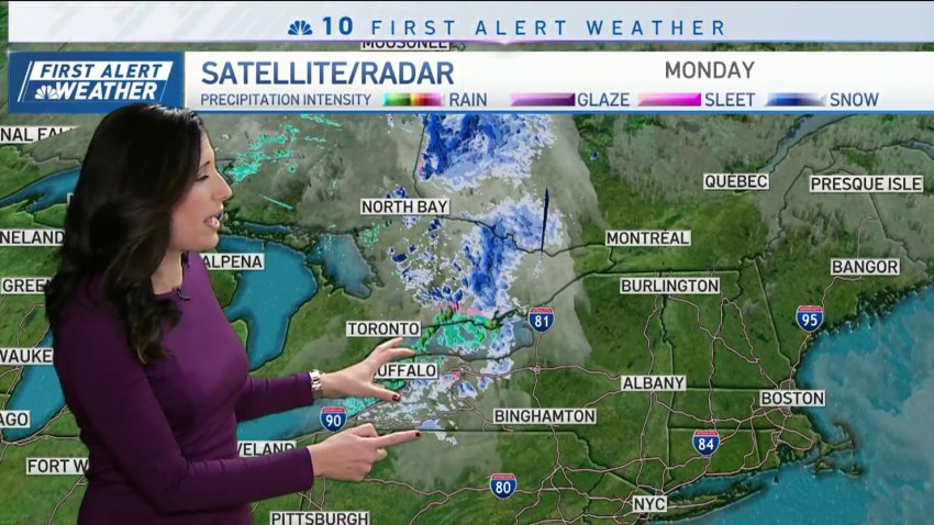
An area of low pressure continues to bring pockets of snow to far northern New England, where a general 4 to 8 inches of wet snow has fallen, with lesser amounts (coating to 2 inches) as far south as Portland, Maine, Winsor, New Hampshire and Wilmington, Vermont. With snow showers dwindling in intensity and coverage, expect only minimal additional accumulations…
-
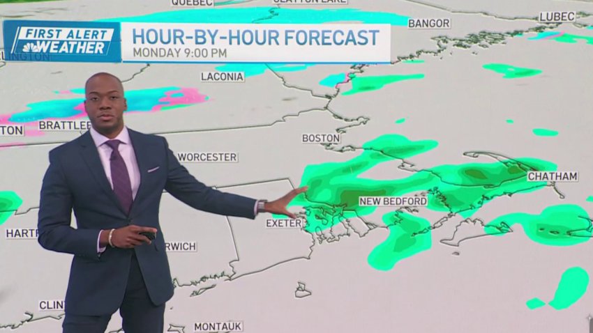
Tuesday will be a quieter but chilly day overall
Monday: Mild, lots of clouds, a few sprinkles/showers, North Country light snow. Highs in the 50s south, 40s north. Overnight Tonight: Early sprinkle departs. Lows in the 30s, 20s north with slick spots. Tuesday: Cooler, more clouds than sun, sprinkle/flurry. Highs around 40. Wednesday: Light snow/rain showers east with a light snow accumulation of a coating to 1″...
-
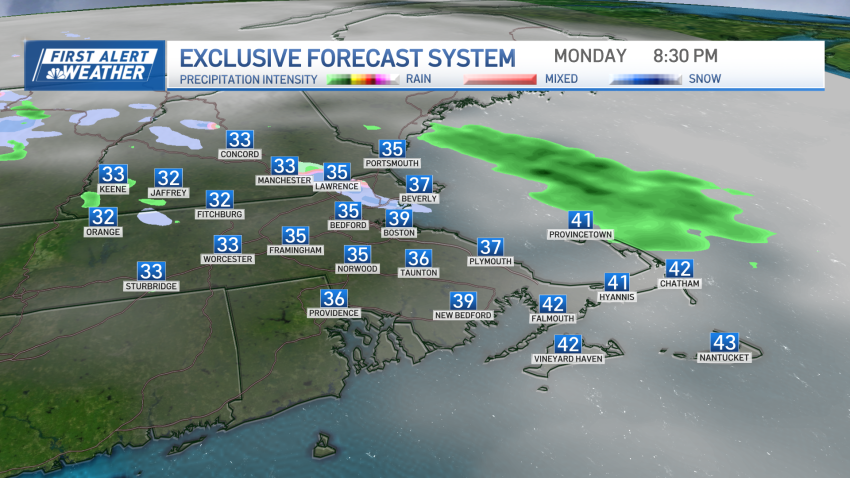
We get into the 50s Monday afternoon
Monday: Mild, lots of clouds, a few sprinkles/showers, North Country light snow. Highs in the 50s south, 40s north. Overnight Tonight: Early sprinkle departs. Lows in the 30s, 20s north with slick spots. Tuesday: Cooler, more clouds than sun, sprinkle/flurry. Highs around 40. Wednesday: Light snow/rain showers east with a light snow accumulation of a coating to...
-
Even with clouds, Monday feels pretty good
Monday: Mild, lots of clouds, a few sprinkles/showers, North Country light snow. Highs in the 50s south, 40s north. Overnight Tonight: Early sprinkle departs. Lows in the 30s, 20s north with slick spots. Tuesday: Cooler, more clouds than sun, sprinkle/flurry. Highs around 40. Wednesday: Light snow/rain showers east with a light snow accumulation of a coating to...
-
Mild start to the week with some sun making a return on Monday
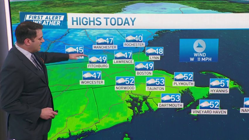
A rainy, raw Sunday turns into a somewhat decent Monday. Quick-hitting downpours and showers moved away Sunday night. Although still damp Monday morning, the day will feature some sun and a drying west wind. Highs should near 50 in most spots. If you’re looking for any signs of winter weather and numbing cold, well, we’re not in the hot...
-
Weather forecast: Cloudy and cold
Thursday: Sun to wispy clouds. Highs in the 40s. Thursday night: Partly cloudy. Lows in the 30s. Friday: Sunny start, showers late. Highs in the 50s south, 40s north. Saturday: More clouds than sun with the chance of a shower. Highs around 50.
-
Chilly, cloudy Thursday night
Overnight Tonight: Partly cloudy. Lows in the 30s. Friday: Sunny start, showers late. Highs in the 50s south, 40s north. Saturday: More clouds than sun with the chance of a shower. Highs around 50.
-
Forecast: Warm-up almost here in Boston
Thursday: Sun to wispy clouds. Highs in the 40s. Overnight Thursday night: Partly cloudy. Lows in the 30s. Friday: Sunny start, showers late. Highs in the 50s south, 40s north. Saturday: More clouds than sun with the chance of a shower. Highs around 50.
-
Mild showers start the weekend, snow ends it for some
As we approach the weekend, New England is undergoing a weather transformation — from recent chill to incoming milder air, most pronounced on Friday. A southwesterly wind flow has begun both at the surface and aloft, initiating the flow of milder air into New England. The first evidence of this milder air came early Thursday morning, before dawn, as a…
-
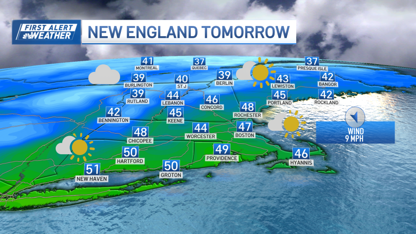
Thursday is one of two days that'll feature above normal temps
Today: Sun to wispy clouds. Highs in the 40s. Overnight Tonight: Partly cloudy. Lows in the 30s. Friday: Sunny start, showers late. Highs in the 50s south, 40s north. Saturday: More clouds than sun with the chance of a shower. Highs around 50.
-
Weather forecast: Cold and cloudy night
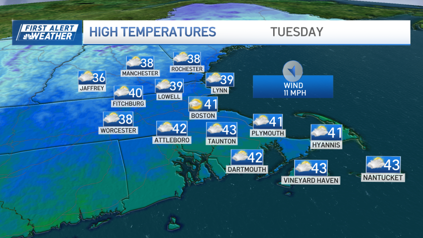
Monday night: Mostly cloudy. Lows around 30, 20s north. Tuesday: Decreasing clouds after an early flurry or sprinkle. Brisk breeze. Highs in the 40s. Wednesday: Sun and clouds. Highs near 50.
-
Chilly overnight, but milder temps ahead
Overnight Tonight: Mostly cloudy. Lows around 30, 20s north.
Tuesday: Decreasing clouds after an early flurry or sprinkle. Brisk breeze. Highs in the 40s.
Wednesday: Sun & clouds. Highs near 50. -
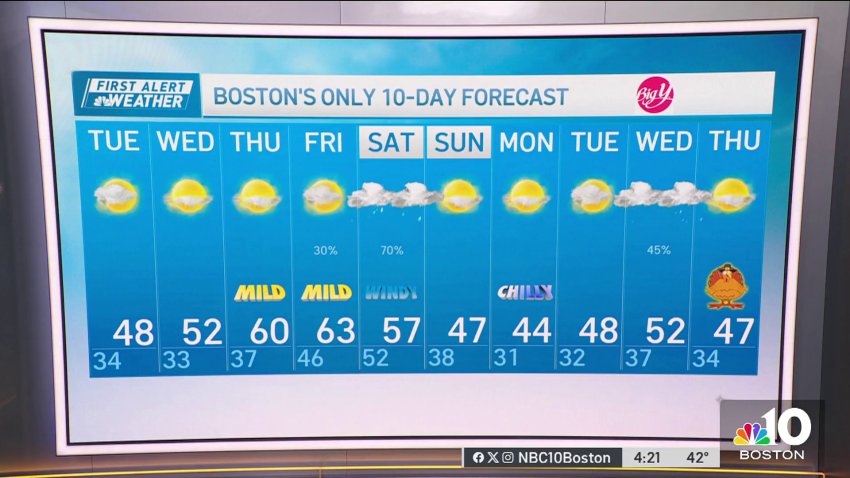
Temperatures will rebound this week after a cold start
Today: Sunshine to afternoon clouds. A few evening sprinkles and flurries, snow showers north. Highs 40-45.
Overnight Tonight: Mostly cloudy. Lows around 30, 20s north.
Tuesday: Decreasing clouds after an early flurry or sprinkle. Brisk breeze. Highs in the 40s.
Wednesday: Sun & clouds. Highs near 50. -
Temperatures will rebound this week after a cold start
Well, it was certainly a cold start to the day with thick frost in spots and temperatures in the teens across parts of the region. We’ll make a decent rebound into the low to mid 40s this afternoon for many under increasing cloud cover. By late afternoon and evening, a disturbance approaching out of Canada will bring some pockets...
-
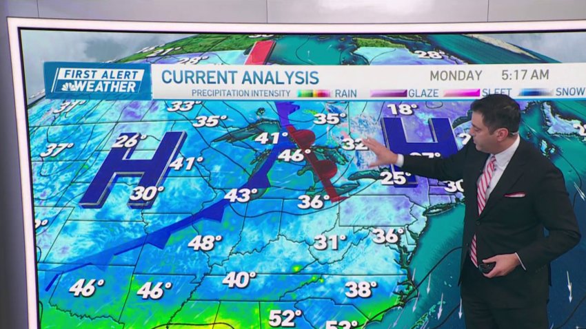
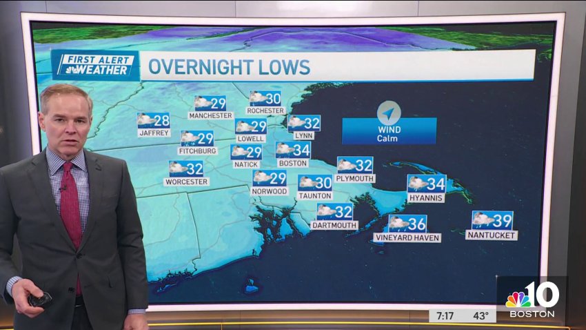
Monday morning is the coldest of the week
Today: Sunshine to afternoon clouds. A few evening sprinkles and flurries, snow showers north. Highs 40-45.
Overnight Tonight: Mostly cloudy. Lows around 30, 20s north.
Tuesday: Decreasing clouds after an early flurry or sprinkle. Brisk breeze. Highs in the 40s.
Wednesday: Sun & clouds. Highs near 50. -
The week starts off with below average temperatures
Sunday morning marked Boston’s first freeze of the season, with temperatures dropping to 31 degrees in the city and reaching the low and middle 20s in surrounding areas. This aligns closely with the typical timeframe for the first freeze, falling within a week of the average first freeze for Boston — Nov. 5. Anticipate another chilly one Monday, as the…
Trending
