A First Alert continues for New England from our weather team Wednesday, though the impacts most certainly aren’t even-handed across the region.
An ocean storm organizing off the eastern shore of New England will continue to strengthen as it pulls north into the Gulf of Maine and, eventually, into the eastern Maine coast Wednesday night. Around this storm center New England will find steady rain, big waves and gusty wind, but not all in the same place at the same time.

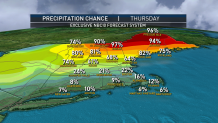
The rain, for example, in southern New England comes in pockets, with plenty of dry space between periodic, mostly light rain with embedded steadier rain at times, but total rain amounts of generally less than half an inch. Heaviest rain is still expected to focus in northern New England, particularly in Maine, where over an inch of beneficial rain will fall on the drought-parched landscape, with a solid soaking of over half an inch probable in central and northern New Hampshire, as well.
Get Boston local news, weather forecasts, lifestyle and entertainment stories to your inbox. Sign up for NBC Boston’s newsletters.
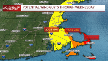
A gusty wind on the west side of the ocean storm will mean northerly gusts to 30 mph in eastern New England Wednesday, with gusts to 40 mph on Cape Cod – not enough to worry about damage, but surely sufficient to create a rather raw feeling with high temperatures generally around and under 70 degrees, and also enough to churn seas as high as 12 feet by Wednesday afternoon, creating pounding surf at our coasts with strong and dangerous rip currents.
Pockets of rain gradually drift north later Wednesday and Wednesday night, settling mostly north of the Mass. Pike after dark, but lingering into early Thursday morning for some, with the northern half of New England finding showers off and on through Thursday!
Further south, a drying west wind Thursday will gust to 40 mph at times but afford increasing breaks of sun as showers kick out early with high temperatures approaching 80 degrees, while pockets of moderate rip currents linger at beaches exposed to the open ocean.
The weekend brings a return of warm, summer weather, with high temperatures not only returning to the 80s but even breaking 90 degrees for some towns away from the coast.

Saturday’s sun will probably be dimmed by a deck of clouds riding well north of a storm center south of New England and while a Saturday afternoon shower can’t be entirely ruled out on Cape Cod, it’s also not likely at this point.
Weather Stories
Sunday looks bright with only slowly increasing humidity in far southern New England, before more humid air takes over Monday and Tuesday of next week with a corresponding rising chance of showers or thunder late Monday, Tuesday and perhaps a shower lingering into Wednesday in our exclusive, First Alert 10-day forecast.


