
It’s a cold start again this Saturday morning with temps in the teens and 20s. Highs today will be in the low 40s with sunshine to start. A drier weather ahead, as a weak and moisture starved area of low pressure heads in by late in the day.
Chances of sprinkles in southern New England as more clouds take over the sky. Mountain snow showers increase in coverage a bit, with a couple more inches of accumulation. Sunday is nice and dry with more sunshine and highs around 40 degrees.
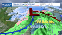
We have a couple First Alert stamps on the 10-day forecast this coming week for possible storms. One for Monday and another for Wednesday. The storm on Monday will head in from the Great Lakes, and bring us scattered rain again.
Get Boston local news, weather forecasts, lifestyle and entertainment stories to your inbox. Sign up for NBC Boston’s newsletters.
Temperatures surge into the 60s and some spots may reach 70 briefly if the sunshine continues long enough in the afternoon. By evening the wind cranks up as a cold front approaches.
Heavy winds expected, with peak gusts from the south, southwest could be 40-60 mph. This is high enough to do some damage and create some power outages. The surf off the south coast will increase a bit too. This coincides with high astronomical tides that are high already throughout the weekend due to the new moon.
Some minor splashover or coastal flooding is possible on south facing beaches Monday. The cold front heads through Monday night and we will see scattered rain, a couple thunderstorms, and a rapid wind direction change by Tuesday morning. Any leftover precipitation overnight will change to snow in higher terrain.
Weather Stories


Be prepared for your day and week ahead. Sign up for our weather newsletter.
As the wind continues from the west, northwest, we expect Lake Effect snow to really get going. Those snow showers may travel to western New England Tuesday, upslope snow in the mountains occurs again. Viewers can expect a snowy Pats game in Buffalo, NY on Monday night.
Highs on Tuesday tumble to the 40s as most places dry off. Wednesday’s storm is a bit different. This one looks to bring a wintry mix of rain and snow into the northeast. Depending on the track, we could see plowable snow for some, a mix to rain for others.
Our Exclusive NBC forecast model has had a storm on the 10-day for a while for this day, so we’re confident in precipitation. We just need to iron out the details on who gets the snow and how much. So stay tuned for updates throughout the weekend!
