Temperatures overnight dropped to below freezing and we have had some freezing fog. The icy spots thaw out once the sun gets higher in the sky this morning. We have another nice and quiet afternoon on this Friday with increasing clouds and highs in the 40s to low 50s.
More warmth heads in for Saturday with highs in the 40s and 50s in southern New England. However, a large area of low pressure is tracking right across central New England from morning noon to night.
We expect mostly rain and gusty south winds for Boston and southeastern New England. Then we change to brief snow Saturday evening as colder air rushes in. About a coating-2” is possible Saturday night in Boston.
Sign up for our Breaking newsletter to get the most urgent news stories in your inbox.
Get Boston local news, weather forecasts, lifestyle and entertainment stories to your inbox. Sign up for NBC Boston’s newsletters.
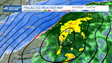
Northwestern New England will see a wintry mix and snow showers all day and evening Saturday. Rainfall of around 1” is possible southeast, and winds could gust around 40 mph along the south and southeastern coastline.
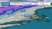
As for the snowfall, with several hours of snow falling northwest we may see 6-12” in Vermont to northern Maine and New Hampshire, and 12-18” far north near the Canadian border. Stay tuned for updates!
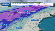
For now we do have a First Alert issued for impacts on travel. The wind changes direction on Sunday, from the west northwest but remaining strong around 40 mph. Sunshine returns and it will be blustery with cooler highs around 40 degrees.
We spring forward one hour Sunday morning, so get ready for that later sunset time (6:48pm in Boston). More spring temps roll in for next week with highs in the 50s throughout. Even St. Patrick’s Day is expected to be very warm with highs in the upper 50s. A couple showers may pass by, but it doesn’t look like a big deal for now.