
What started as a warm and wet week will finish with a winter feel.
Temperatures will hover in the 40s for another day, as rain and scattered showers linger Thursday. There's an isolated risk for a thunderstorm off of the coast and for Martha’s Vineyard. Storms aren't expected to be widespread.
STAY IN THE KNOW
Watch NBC10 Boston news for free, 24/7, wherever you are. |
|
Get Boston local news, weather forecasts, lifestyle and entertainment stories to your inbox. Sign up for NBC Boston’s newsletters. |
With temperatures dropping and residual moisture, there will be the risk of a few ice patches. Winter weather alerts have been issued by the National Weather Service. While confidence is low, it looks more promising across Worcester County between Leominster and Fitchburg, through the Monadnock Highway of Southern New Hampshire and the lower Merrimack River Valley.
Icing amounts will be less than a tenth of an inch, but will pose danger for untreated roadways and elevated surfaces.
329 medal events. 32 sports. Endless drama. Catch all the action at the Paris Olympics. Sign up for our free Olympics Headlines newsletter.
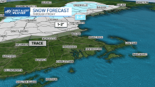
After early showers, Thursday features cloudy conditions, similar to Wednesday. Another installment of change comes about on Friday as an upper-level disturbance brings rain and snow showers through eastern Massachusetts. With this, a mix of rain and wet snow move in between midday and the late afternoon timeframe. Amounts are likely on the lower end, with trace amounts through the North Shore to Worcester, with higher amounts up to 2 inches along and north of Route 2.
This event will be an on-the-border scenario as temperatures are near freezing at the ground's surface, but cooling aloft.
Local
In-depth news coverage of the Greater Boston Area.


As rain and snow winds down, temperatures continue to fall throughout Friday evening. This will mark the return of wind chills, as Saturday morning feels like temperatures return to the 20s. This will be more in line with what we'd expect for an early-to-mid January.
The weekend looks markedly drier than the preceding days. High temperatures return to near-seasonable average in the upper 30s and lower 40s for the remainder of the forecast period.
