
Our weather is pattern is fairly quiet, especially by December standards. This time of year, though, any bit of a breeze certainly adds a bite to the air, and that’s exactly what we’re experiencing out there.
The wind will stay active Monday night and temperatures will drop back in the 20s to low 30s (not as cold as Monday morning). Tuesday, the wind diminishes somewhat and temperatures will be pretty seasonable, running either side of 40. Expect sun and clouds with some mountain snow showers and flurries in the far North Country.
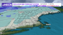
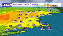
Midweek brings some change, as a storm will pass close enough to New England for widespread precipitation. Right now it looks like a cold rain in southern New England, which may start as touch of freezing rain inland. This may make for a bit of a slippery Wednesday morning commute – keep in mind, all it takes is a trace of freezing rain to really slicken up the roads.
Get Boston local news, weather forecasts, lifestyle and entertainment stories to your inbox. Sign up for NBC Boston’s newsletters.
Northern New England will see accumulating snow away from the coast, on the order of a few inches in spots.
Behind this disturbance, it’s another brisk and quiet day Thursday. Some flurries and light snow showers will be possible Thursday night into early Friday, but it doesn’t look like more than ambiance type stuff.
Weather Stories


Christmas Day itself will feature another round of light precipitation, most likely rain in southern New England and snow in far western and northern New England. It's worth watching for sure – but no major weather headaches are currently in the forecast right through the middle of next week, as seen in our exclusive 10-day forecast.
