
Temperatures continue to climb Friday with a sun/cloud blend. The deciding factor in reaching 50 (or better) will be the sun and the wind direction.
South winds will favor cooler readings on the Cape(s)/Islands and across most of southeast Massachusetts. Boston could sneak into the elite "fitty" club, but it may be a challenge. But we're on firm ground for 50 throughout MetroWest, Greater Worcester, outer Route 2 and all of southern New Hampshire.
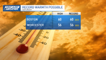
Record-setting high temps Saturday
Get Boston local news, weather forecasts, lifestyle and entertainment stories to your inbox. Sign up for NBC Boston’s newsletters.
Saturday, the warmth will culminate in a record-setting afternoon. Sun will blend with clouds again, but the airmass is a touch warmer. Low 60s are possible in the aforementioned warm spots. Ironically, (or maybe not) the records we're attempting were set exactly one year ago. As far as showers are concerned, we'll wait until late day or overnight for them to zip through with a frontal passage.
And that front will begin the cooldown into Sunday. This is a "critical mass" moment in the forecast as it sets the table for the storm on Monday night and Tuesday. Right now, there doesn't seem to be a ton of cold, but all we need is a temp near freezing (obvi).
How much snow will Massachusetts get?
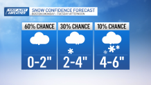
The storm will be strong enough to overcome the marginally cold air, so there's also a consideration. The track shifted south Thursday, so that means we're colder in the middle and upper atmosphere – another lean in the direction of a mostly-snow storm.
Weather


There's still plenty to play out in the days ahead, but these signs are pointing to some accumulation across the Commonwealth – barring a sudden shift away from us.
Cold, windy weather will follow the storm into the middle of next week, so enjoy the mild temps while they last.
