
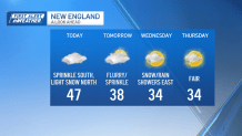
Monday: Mild, lots of clouds, a few sprinkles/showers, North Country light snow. Highs in the 50s south, 40s north. Overnight Tonight: Early sprinkle departs. Lows in the 30s, 20s north with slick spots. Tuesday: Cooler, more clouds than sun, sprinkle/flurry. Highs around 40. Wednesday: Light snow/rain showers east with a light snow accumulation of a coating to 1″ for some. Highs in the 30s.
An area of low pressure continues to bring pockets of snow to far northern New England, where a general 4 to 8 inches of wet snow has fallen, with lesser amounts (coating to 2 inches) as far south as Portland, Maine, Winsor, New Hampshire and Wilmington, Vermont.
With snow showers dwindling in intensity and coverage, expect only minimal additional accumulations in the far North Country of a coating to 2 inches with some higher totals in northern Coos County and central and northern Maine (2 to 4 inches).
WATCH ANYTIME FOR FREE
Stream NBC10 Boston news for free, 24/7, wherever you are. |
Farther south, we've been drying out, though clouds have been stubborn. Expect highs in the 40s to low 50s Monday afternoon with the exception of Maine, where we'll be in the 30s.
Get updates on what's happening in Boston to your inbox. Sign up for our News Headlines newsletter.
After dipping into the 20s and 30s Monday night with some slick spots developing, Tuesday will be a quieter but chilly day overall.
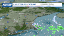
Aside from a sprinkle or flurry, we'll be mostly dry with highs in the 30s to low 40s. Tuesday night into Wednesday, some upper level energy and a slight wind shift will focus some areas of snow in eastern Massachusetts, enhanced on the South Shore to the upper Cape, though only a coating to perhaps an 1 inch is expected through Wednesday morning.
Nonetheless, it will coincide with the Wednesday morning commute and may briefly cause some slow travel or slippery spots in those areas. Brighter skies will greet us on Thursday and Friday ahead of a significant warm up this weekend.
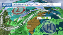
Both Saturday and Sunday are likely to feature temperatures in the 50s. With mild air in place, the next round of widespread precipitation will be in the form of rain, arriving late Sunday into Monday followed by a shot of cooler air as seen in our exclusive 10 day forecast.