
The atmosphere is about as marginal for rain versus snow as it could possibly be in southern New England, and that’s been playing out with flips and flops between rain and snow for the Boston Metro and areas near and south of the Massachusetts Turnpike.
Farther north, the flipping and flopping has turned to a decided and resounding flop toward snow – which will continue falling, at times heavily, through the afternoon. Temperatures just barely cold enough for snow usually make big, fat snowflakes and that will be the case for much of the day. These can accumulate fairly effectively, but also tend to start melting after reaching the ground, thanks to ground temperatures above freezing and air temperatures also above freezing.
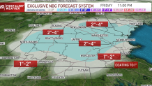
The end result is snow that’s slow to add up, but does get the job done accumulating. Our First Alert team is forecasting a swath of 3 to 4 inches of snow for some of north-central Massachusetts to southern New Hampshire and southeast Vermont, with a broader area of one to two inches north and west of Boston and in northern New England.
Get Boston local news, weather forecasts, lifestyle and entertainment stories to your inbox. Sign up for NBC Boston’s newsletters.
South of the Mass. Pike – particularly in southeast Massachusetts– more rain will fall and little significant snow is expected. In areas that near and exceed two inches of snow accumulation, roads will deteriorate Friday afternoon and become slush and snow covered for a time, especially where not treated.
Snow and rain ends Friday evening around dinnertime, then temperatures drop below freezing overnight, freezing the wet snow in place and causing slick spots on the roads that will require continued treatment in spots. Saturday and Sunday are fairly quiet. A disturbance aloft Saturday will fill the sky with lots of bubbling clouds after limited morning sunshine, and from those clouds a few flurries and sprinkles may fall Saturday afternoon, with scattered snow showers in the mountains.
Local
In-depth news coverage of the Greater Boston Area.


Sunday brings lots of sun, but a cool day with highs in the 30s, though neither weekend day features a lot of wind, with a northerly and northwest breeze at about 5 to 15 miles per hour both days. Our First Alert team has been watching three disturbances in the 10 day forecast next week: Monday, Wednesday and Friday night to Saturday.
The first two should be relatively quick-moving, meaning snow/rain showers, at worst, would be the impact, with a potential one or both actually slide south of us entirely. Friday night to Saturday’s disturbance looks stronger and holds more potential to become a developing storm of more significant snow and/or rain – probably both, depending on your location and storm track.
Regardless, next week finally starts to feel and look more like January, even if it ends up a few degrees above normal for temperature.
