
-
Goodbye to a legend: Meteorologist Matt Noyes
On his last day with NBC10 Boston, the team shared their love for Chief Meteorologist Matt Noyes, along with some fond — and wacky — memories.
-
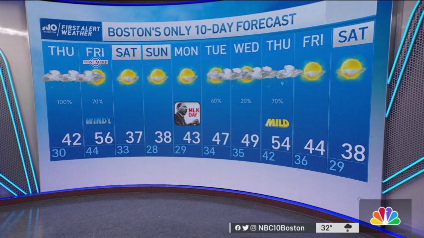
Weather Forecast: Snow and Rain Showers
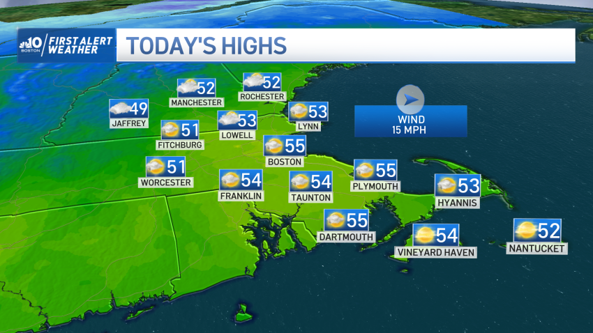
Wednesday night: Overcast. Lows in the 20s. Thursday: Snow and rain showers. Highs around 40. Friday: Drying out Friday afternoon. Highs in the mid-50s. Gusting over 30 mph 3-10 a.m.
-
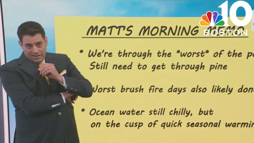
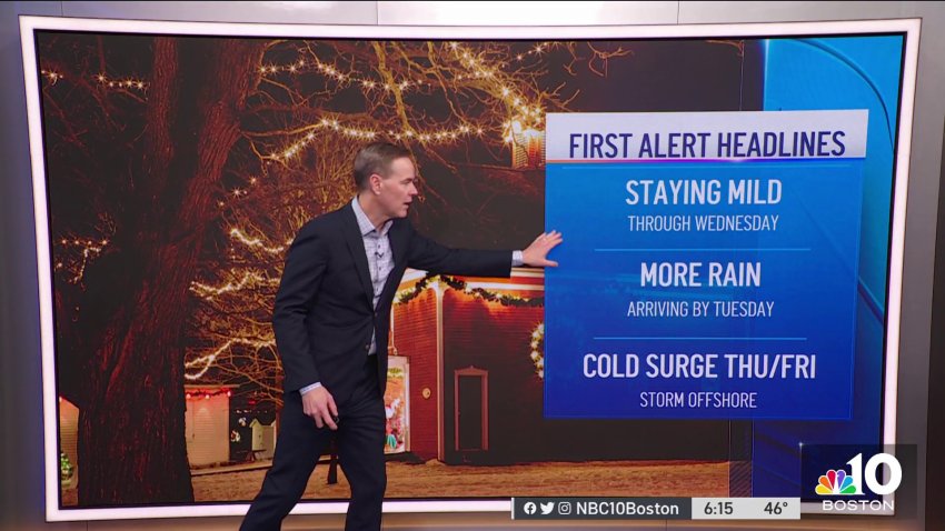
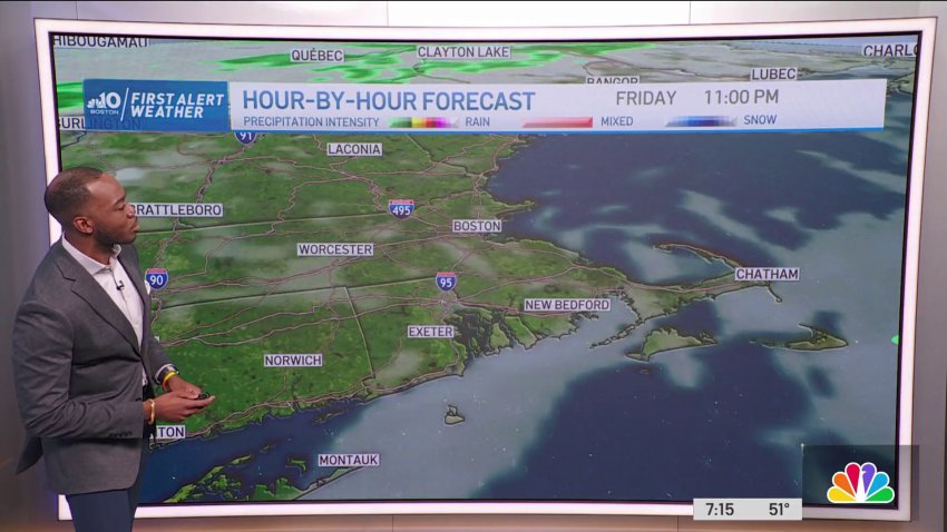
FIRST ALERT: Winter Storm to Bring Snow, Rain and Wind This Week
Winter’s chill is evident across New England on Wednesday, but it is on borrowed time – set to stick around just long enough to drop snow in spots before retreating for a mild, windswept rain Friday. Nonetheless, highs in the 30s will feel like the 20s, with a slight northeast breeze Wednesday afternoon that blows gently across the ocean,...
-
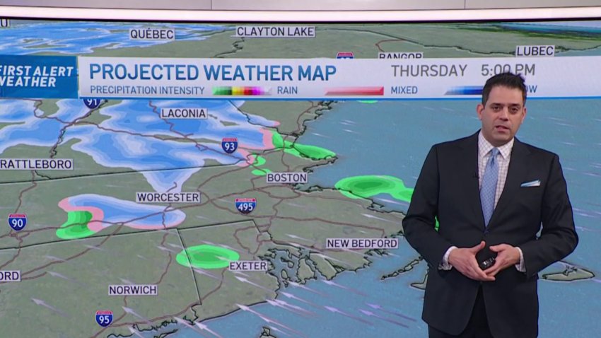
Snow and Rain Showers Thursday Ahead of First Alert on Friday
Today: Variable clouds, coastal flurries. Highs in the 30s. Overnight Wednesday Night: Overcast. Lows in the 20s. Thursday: Snow & rain showers. Highs around 40°.
-
Weather Forecast: Sun Before Clouds
Friday night: Partial clearing, icy spots on roads. Lows around 30. Saturday: Some morning sun, then mostly cloudy, chance flurry or sprinkle. Highs in the lower 40s, 30s north. Sunday: Sun to some clouds late, cool. Highs in the 30s.
-
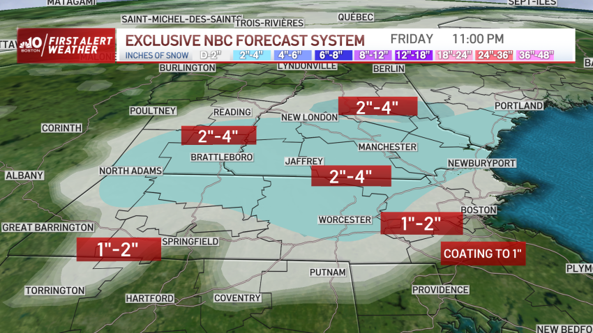
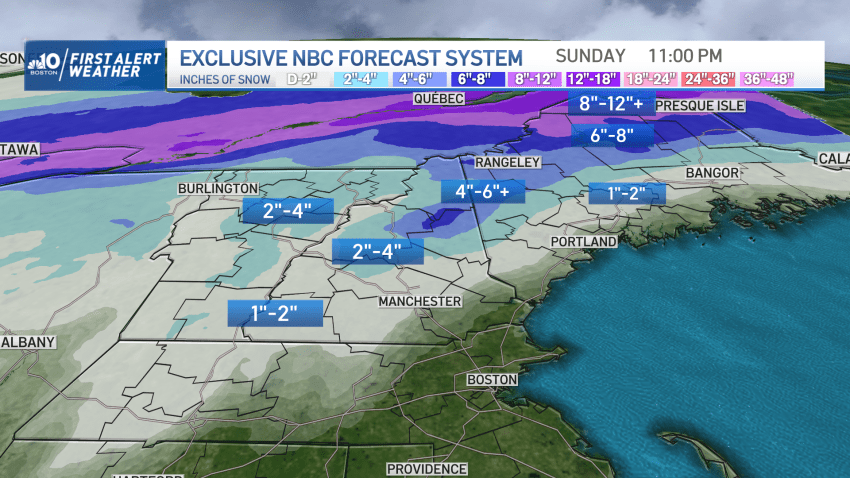
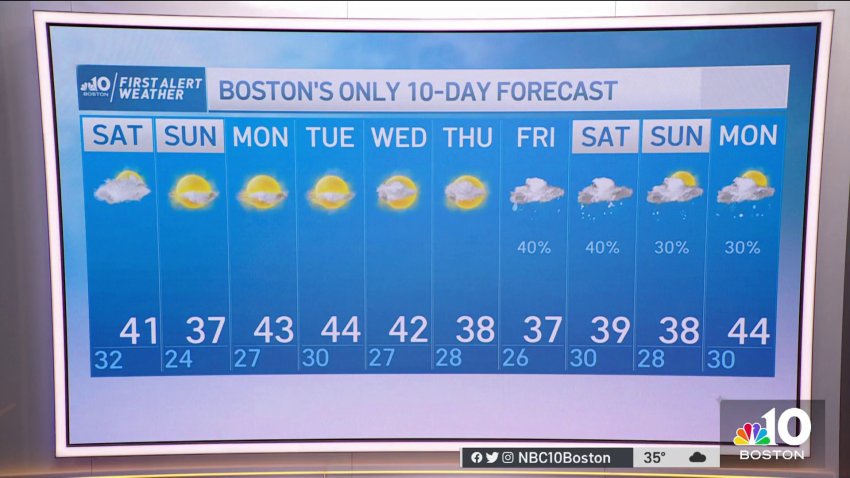
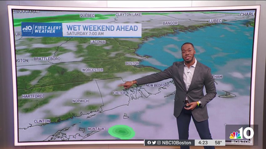
FIRST ALERT: Snow Sticks for Many Friday Ahead of Seasonable Weekend
The atmosphere is about as marginal for rain versus snow as it could possibly be in southern New England, and that’s been playing out with flips and flops between rain and snow for the Boston Metro and areas near and south of the Massachusetts Turnpike. Farther north, the flipping and flopping has turned to a decided and resounding flop...
-

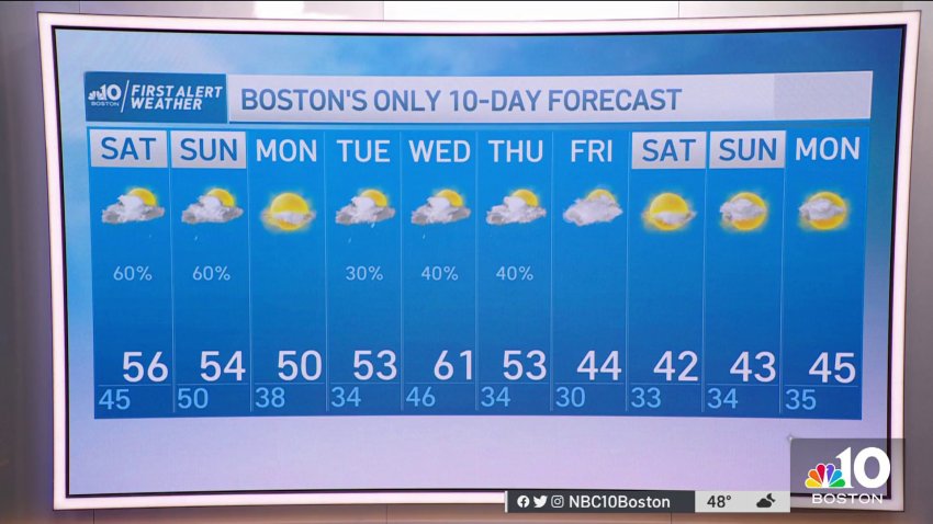
Forecast: Monday in 50s as Mild Air Sticks Around
Overnight: Partly cloudy, colder. Lows in the mid 30s.
Monday: Mostly sunny. Highs around 50.
Tuesday: Mostly cloudy, pm rain. Highs in the 50s. -
Forecast: 2023 Off to Mild Start
Sunday Evening: Temps in the 40s, partly cloudy.
Overnight: Partly cloudy, colder. Lows in the mid 30s.
Monday: Mostly sunny. Highs around 50.
Tuesday: Mostly cloudy, pm rain. Highs in the 50s. -
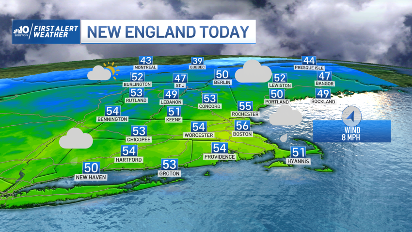
Temperatures Around 50s, 60s as Mild Air Kicks Off New Year
We have more mild temperatures running well above normal for this time of the year.
-
Mild Weather Continues on the First Day of 2023
We’re ringing in 2023 the way we left 2022: with more mild air. Rain has departed, and the drier air will work in on the heels of a gusty northwest wind. The wind backs off tonight, but only slightly cooler air will dip in tomorrow. All looks bright and (somewhat) balmy for the Winter Classic at Fenway, but even tomorrow…
-
Mild Weather Continues on January 1st
New Year’s Day Today (Sunday): Partly cloudy, patchy fog. Sun breaks out, breezy. Highs in the 50s, 40s north. Overnight Sunday Night: Partly cloudy, colder. Lows in the mid 30s. Monday: Mostly sunny. Highs around 50.
-
New Year's Day in the High 50s
Rain showers tonight (Saturday) will stop around 2 a.m., making way for mild temperatures and sunshine tomorrow.
-
Warmest New Year's Eve Since 1992
Record-setting New Year’s temperatures, and rain showers will continue through midnight tonight (Saturday), with showers ending at 2 a.m. tomorrow. New Year’s Day will be bright with temperatures in the low 50s. Colder weather expected this upcoming Thursday and Friday.
-
Breeze and Light Rain for First Night Boston
Today (Saturday): Cloudy, showers fill in by afternoon, late rain. Highs in the mid 50s. Overnight Saturday Night: Scattered showers. Temps around 50 at midnight. Lows in the 40s, developing fog. New Year’s Day Sunday: Early showers, patchy fog, sun breaks out, breezy. Highs in the 50s, 40s north.
-
Mild Air is Here to Stay for the First Days of 2023
Showers continue to fill in today to wrap up 2022. The new year doesn’t mean we wrap up with the warm temps, however. Mild air is here to stay for the first several days of 2023. Cloudy skies, fog near the south coast, and scattered showers will be off and on through early afternoon. By mid afternoon the rain...
-

New Year's Weekend Promises Warm Weather, With Rain & ‘Champagne' Showers
The year will end on a high note, with record breaking temperatures of Friday carrying into New Year’s Eve for New England. Temperatures will run 10-15° above average, with most areas of Southern New England reaching the mid 50s. Saturday will start with cloudy conditions across the region, as a weather system approaches. Those clouds will prohibit the region...
-
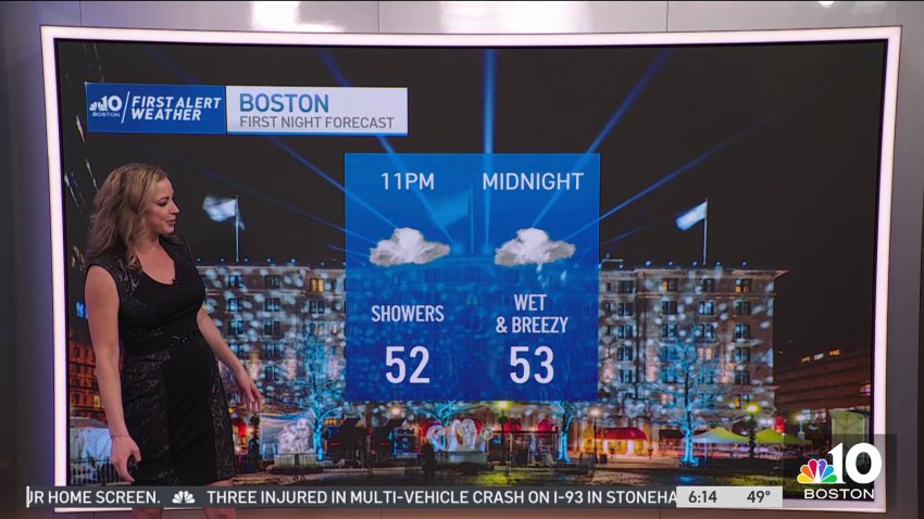
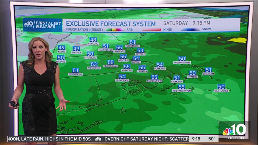
Wet and Breezy First Night in Boston
Today (Saturday): Cloudy, showers fill in by afternoon, late rain. Highs in the mid 50s.
Overnight Saturday Night: Scattered showers. Temps around 50 at midnight. Lows in the 40s, developing fog.
New Year’s Day Sunday: Early showers, patchy fog, sun breaks out, breezy. Highs in the 50s, 40s north.
-
Weather Forecast: Showers on New Year's Eve
Friday night: Partly to mostly cloudy. Lows in the 40s, 30s north. New Year’s Eve: Cloudy, midday and afternoon showers, evening and First Night rain. Highs in the 50s. New Year’s Day: Any early showers depart for breezy breaks of sun. Highs in the 50s, 40s north.
-
Weather Forecast: Mild Night Before New Year's Eve
Friday night: Partly to mostly cloudy. Lows in the 40s, 30s north. New Year’s Eve: Cloudy, midday and afternoon showers, evening and First Night rain. Highs in the 50s. New Year’s Day: Any early showers depart for breezy breaks of sun. Highs in the 50s, 40s north.
-
Cloudy and Wet Weekend for Boston
Overnight Friday Night: Partly to mostly cloudy. Lows in the 40s, 30s north. Saturday: Cloudy, midday & PM showers, evening & First Night rain. Highs in the 50s. New Year’s Day Sunday: Any early showers depart for breezy breaks of sun. Highs in the 50s, 40s north.
Trending
