We saw a hot day across much of the region on Memorial Day, and some will see the heat and humidity again Tuesday!
The rest of Monday evening will be warm, dry, and muggy with the exception of far northern Maine where we’ll see a few showers developing along a cold front.
STAY IN THE KNOW
Watch NBC10 Boston news for free, 24/7, wherever you are. |
|
Get Boston local news, weather forecasts, lifestyle and entertainment stories to your inbox. Sign up for NBC Boston’s newsletters. |
It’ll remain muggy and mild overnight for much of the region with the exception of central Maine where we’ll see the greatest threat for showers as our back door cold front sags to the southwest. Lows will be mostly in the 60s, and 50s across Maine.
329 medal events. 32 sports. Endless drama. Catch all the action at the Paris Olympics. Sign up for our free Olympics Headlines newsletter.
Summer heat remains in place once again Tuesday with the exception of the southern New England coast up to Maine where a back door cold front will play spoiler. As a matter of fact, temperatures will start out warm, in the 70s along the coastline, but rapidly drop into the 60s as the frontal system moves through during the mid to late morning hours.
At which time, we’ll see a brief period of winds gusting out of the northeast, but will subside once the front moves through. Inland locations will reach the mid 80s to 90 during the afternoon with a few showers and thunderstorms popping up later in the day and evening.
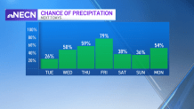
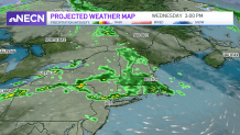
By Wednesday, all of New England cools off under mostly cloudy skies as a wave of low pressure moves through the region bringing some beneficial rain showers along with some thunder that lasts into Wednesday night.
Thursday will remain mostly cloudy with cooler than average temps along with the threat for afternoon showers.
Local
In-depth news coverage of the Greater Boston Area.


More rain showers are possible again Friday but we’re seeing a bit of uncertainty as for the timing as another wave of low pressure moves through the region.
Stay tuned!