It's a sun-filled Sunday!
Another gorgeous day today with plenty of sunshine, low humidity and pleasant temperatures in the mid to upper 70s along the coast. The interior could see values in the mid to lower 80s. Let’s enjoy today’s picture-perfect weather with dry and cool temperatures for tonight.
STAY IN THE KNOW
Watch NBC10 Boston news for free, 24/7, wherever you are. |
|
Get Boston local news, weather forecasts, lifestyle and entertainment stories to your inbox. Sign up for NBC Boston’s newsletters. |
As high pressure slides south of the region, we’ll start to see a warming trend as of tomorrow with some breeze. In the meantime, this dry and pleasant weather will stretch overnight into the start of the work week.
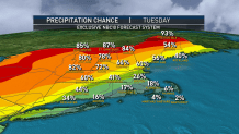
By Tuesday, it will turn warm and the humidity will be on the rise through Wednesday. Dewpoint will jump to the upper 60s. Most of Tuesday should remain dry with a threat for some showers and possible thunderstorms late in the day and evening that could affect afternoon/evening commuters in Boston.
329 medal events. 32 sports. Endless drama. Catch all the action at the Paris Olympics. Sign up for our free Olympics Headlines newsletter.
The latter part of the week still looks somewhat unsettled due to a cold front slowing down over the region or stalling over southern New England. It all depends on the location and timing of this front. We’ll continue to track the risk for storms. For now, late afternoon Tuesday is of greater concern with the front to our west and near tropical humidity.
In the meantime, enjoy the beautiful weather today. Perfect for outdoor activities such as the beach, park, outdoor dining, hiking or some backyard grilling. Enjoy, stay safe, and don’t forget the sunblock.
Local
In-depth news coverage of the Greater Boston Area.