
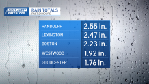
After a late-season winter storm delivered a record breaking 2.23” of rain in Boston, and nearly two feet of snow for Maine, New Hampshire and Vermont, cold air is drawn in, in its wake.
Sunday morning starts with single digit wind chills and cold air overhead. Strong breezes from the northwest will gust between 15 and 30 miles an hour. The sun will be out in the afternoon with passing clouds overhead, so highs do recover in the upper 30s to low 40s. Even with the storm’s departures, the week will start cold.
See all the weather alerts here.

Get Boston local news, weather forecasts, lifestyle and entertainment stories to your inbox. Sign up for NBC Boston’s newsletters.
Highs on Monday, are in the 30s too…and Tuesday doesn’t promise to be that much better. A weak offshore system will keep clouds in the forecast on Tuesday, with occasional showers. 50s are very pronounced through the rest of the week though with an upcoming warm front and storm system.
It’s warmer than yesterday’s storm, but not as strong, so it’s very likely that the wide-scale impact will bring rain back again as we close out the month. It’s precisely what Boston doesn’t need,as we sit at nearly 6.5” of rainfall for the month.
For as lion-like as the month has seemed, going out like a lamb is the least that it could do. And I think it will. Easter weekend is trending warmer, and dry for outdoor festivities, with highs in the 50s.
Be prepared for your day and week ahead. Sign up for our weather newsletter.
