
We continue to enjoy another dry afternoon, although temperatures are remaining cool. We’re staying in the 50s and we’ve been watching our wind gusts rise to 20 mph in the south.
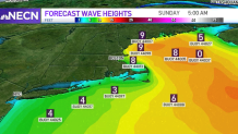
This has been churning up our seas, and waves of up to 10 feet high this morning are dropping just a bit Friday evening before retaking those 9 to 13 foot high waves Saturday morning. Beach erosion and splashing in seawalls will continue during the high tides until Saturday night.
STAY IN THE KNOW
Watch NBC10 Boston news for free, 24/7, wherever you are. |
|
Get Boston local news, weather forecasts, lifestyle and entertainment stories to your inbox. Sign up for NBC Boston’s newsletters. |
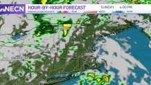
Inland, we’ve enjoyed sun in the north and west, but more clouds continue covering the south as the low pressure that’s heading in Friday night keeps getting closer. We’ll see showers taking over the south by 3 a.m. and be waking up to slippery roads in the Boston area.
Get top local stories in Boston delivered to you every morning. Sign up for NBC Boston's News Headlines newsletter.
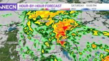
Even though light showers will make their way in, allowing for a few places to remain drier, the eastern side of New England is the one to be affected the most by the evening hours.
Heavy downpours are expected, spreading into the northeast, gusting up to 40 mph and producing between 1 to 2 inches of rainfall. This might cause some ponding and flooding near the storm drains affected by the remaining debris that wasn’t cleaned out or in the usual spots affected by poor drainage.
How’s Halloween looking? The forecast keeps improving.
Weather
The far northern areas of Vermont and New Hampshire might see some rain, but toward the central and southern areas of New England expect breaks in the clouds between a mix of isolated light showers.
Overall, we're looking at a much better forecast than what we had two days ago.
November is starting just a bit warmer than normal, but temperatures will rapidly drop by Tuesday into the 50s. The quiet weather will last until Wednesday, as a system moves in but is not anticipated to cause much trouble.