
Showers continue to fill in today to wrap up 2022. The new year doesn’t mean we wrap up with the warm temps, however. Mild air is here to stay for the first several days of 2023.
Cloudy skies, fog near the south coast, and scattered showers will be off and on through early afternoon. By mid afternoon the rain becomes more steady and widespread around New England.
STAY IN THE KNOW
Watch NBC10 Boston news for free, 24/7, wherever you are. |
|
Get Boston local news, weather forecasts, lifestyle and entertainment stories to your inbox. Sign up for NBC Boston’s newsletters. |
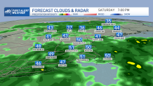
Temperatures will still manage to reach the mid 50s on a gusty southwest wind. That wind is more of a nuisance than anything since gusts will push 20-25 mph tonight.
329 medal events. 32 sports. Endless drama. Catch all the action at the Paris Olympics. Sign up for our free Olympics Headlines newsletter.
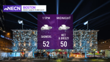
Yesterday we hit several daily record highs in the northeast, evening tying the daily record high in Boston (63, 1984). With more clouds around and rain, the air will stay cooler but still running 10-20 degrees warmer than normal for this time of the year and highs in the 50s. Rain remains for First Night in Boston through midnight.
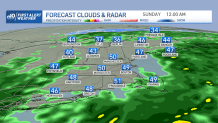
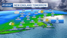
The showers start to taper around midnight and head offshore by dawn Sunday. Temps don’t fall much, with lows in the 40s and areas of fog. Temps still warm to the 50s for New Year’s Day, northern New England in the 40s, and emerging sun and a breeze for all.
We cool a tad for Monday with more sun, but still will see highs in the 30s and 40s north, to around 50 south.
Then here comes another warm up! Our wind switches to more southwest Tuesday into Wednesday as we see 50s to low 60s.
A warm front lifts through Tuesday night, so some showers will be around before temps surge to the low 60s Wednesday. Wednesday night into Thursday we have another wave of showers. Then cooler air moves in behind a cold front.


There is the potential for a coastal storm sometime Friday to bring in more precipitation to southeastern New England. With some cold air wrapping around the low, we may see some snow in the interior and rain at the coast.
But stay tuned, since we are still several days away and a lot can change with a rather unsettled weather pattern for midweek next week. Colder air, rather, more seasonable temps, will return for the rest of the 10-day and next weekend.
