
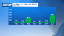
A rainy, raw Sunday turns into a somewhat decent Monday. Quick-hitting downpours and showers moved away Sunday night. Although still damp Monday morning, the day will feature some sun and a drying west wind.
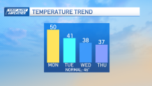
Highs should near 50 in most spots.
If you're looking for any signs of winter weather and numbing cold, well, we're not in the hot seat for either here in southern New England. Northern New England, on the other hand, has seen big snow in the higher elevations, setting some ski resorts up for their best start in years.
Get Boston local news, weather forecasts, lifestyle and entertainment stories to your inbox. Sign up for NBC Boston’s newsletters.
We may not have mid-winter cold, but there are some signs we could see some flakes flying by midweek.
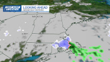
As colder air funnels in on a chilly northwest wind Tuesday, we'll drop the temperatures a solid 10 degrees. Then, as the wind starts turning to the northeast along the coast (and offshore), we should see some ocean-effect snow showers flare up on Wednesday.
Part of this is the wind direction, but the other critical part will be the colder air moving in overhead.
This will destabilize the atmosphere and keep the snow showers – and migrating at random – rolling through much of the day. Of course, snow showers of this nature are a crap shoot in terms of accumulation.
Weather

We could see some light coatings in one town, and nearly nothing in surrounding towns. It all depends on the orientation of the snow bands.
In any event, it's chilly. Highs remain in the mid/upper 30s both Wednesday and Thursday. We'll bounce back by the end of the week, with another mild storm projected to arrive by...you guessed it, the end of the weekend.
Temperatures leading up to the rain will leap back into the 50s. Have a great workweek!
