
A large ocean storm that hammered Nova Scotia's Cape Breton Island over the weekend is slowly decaying over the open waters of the Atlantic. Its parent low in the upper atmosphere will be enough to destabilize the atmosphere and trigger a few ocean-effect snow showers across southeast Massachusetts Tuesday.
Any accumulations will be scant and scattered. Perhaps we could see a random coating in spots that hold on to a snow shower long enough. Temperatures will only rise to the mid/upper 30s. Away from the coast, the sun will be bolder and brighter. No worries for any flurries or snow showers.
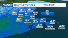
We'll shake the clouds and snow threat Wednesday. Highs will bounce back near 40 as this day marks the beginning of a warmup. We'll build through the 40s and head to the 50s by the end of the week.
Get Boston local news, weather forecasts, lifestyle and entertainment stories to your inbox. Sign up for NBC Boston’s newsletters.
The massive storm plowing through Southern California is heading east, but will gradually unravel in the days ahead. By the time it reaches us, it will be a feeble band of showers on Saturday. Mild air will also surge ahead of this system, pushing us through the 50s on a steady southwest wind.
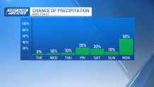
We'll see the cold slowly work in between Sunday and Monday, then watch a developing storm into Tuesday. Solutions range from rain to snow depending on how much cold precedes the event, so we'll keep following the evolution in the coming days.
Weather


We do know the pattern will shift after this storm passes, with cold expected to grip the entire east well into the following weekend.
