Monday's quiet weather is welcome as parts of the region continue the clean up from Sunday's storm. Highs will top out in the 30s Monday afternoon with ample sunshine and light winds.
Meanwhile, the Gulf Coast states are contending with a dangerous situation as numerous severe thunderstorms, including the risk of strong tornadoes, are forecast Monday. And that is our next storm, slated to move up the eastern seaboard Tuesday and arrive for us Tuesday evening.
This is likely to be a moderate to high impact event across the region, with damaging wind gusts, a burst of interior snow, heavy rainfall and localized flooding along with coastal concerns.
Get Boston local news, weather forecasts, lifestyle and entertainment stories to your inbox. Sign up for NBC Boston’s newsletters.
Track Wednesday's storm with live weather radar
Rain and snow will arrive in southwestern New England first, 2 to 4 p.m. Tuesday, and spread east generally 4 to 6 p.m. A period of snow will be confined to inland locations Tuesday evening before flipping over to rain as mild air moves in.
Snow storm forecast
Before the changeover, snow accumulation of a few inches of for interior southern New England (outside of 495), with totals ramping up to 3 to 6 inches from western Massachusetts, southern New Hampshire and points north is likely with 6 to 8 inches from southern Vermont into much of northern New England with a jackpot zone of 8 to 12 inches with over a foot from eastern Grafton county New Hampshire to Carroll county and western Maine.
Amounts will be much lower for Maine along and south of the turnpike, with 4 to 6 inches near Bangor and a couple inches in Portland, for example. For the remainder of Tuesday night into Wednesday morning, rain falls and falls hard at times with downpours, isolated thunder possible with 1 to 3 inches expected and flooding as a result.
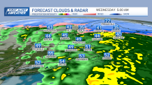
A combination of the snowpack, rain amounts and melting with mild air will mean significant drainage issues and a spike into flood stage for many of our rivers and streams. The back edge of the rain will come in 7 to 9 a.m. on Monday with just some leftover showers after that and temperatures falling through the 40s after reaching the 50s briefly.
Power outages possible in Mass. due to strong winds
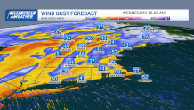
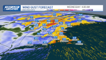
Meanwhile, the wind will be howling out of the southeast; numerous gusts 4 to 60 miles per hour are likely, particularly for the western slopes of the Green mountains Tuesday night and much of eastern New England pre-dawn Wednesday, resulting in scattered to numerous outages.

Some isolated gusts 60 to 70 mph are possible. The wind will ease substantially by mid morning Wednesday.
After that, our weather quiets again, with clearing skies Wednesday afternoon and highs in the 40s Thursday and Friday.
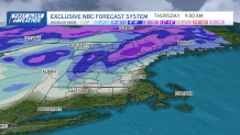
Next snow storm in Boston arrives Friday night
Another storm will arrive Friday night and last into Saturday and may be very similar to this next one; a multifaceted event with a burst of snow changing to rain and damaging wind gust potential.
Stay tuned for updates this week.