
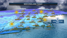
Most of New England isn’t digging out, but we are brushing off!
For some, it was a full-fledged dig, where over half a foot of snow fell in parts of western Massachusetts, with Berkshire County leading the snow tally with nine inches measured in Lenox.
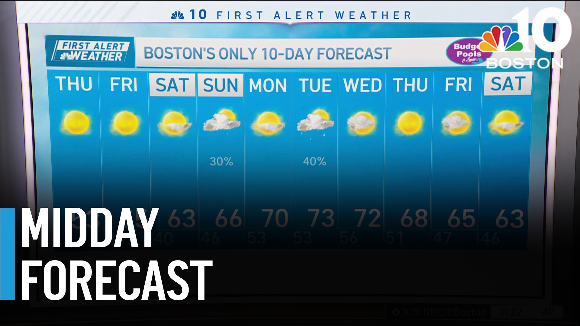
For others, a coating to two inches was more commonplace. While morning flurries depart for emerging sunshine, the wintry chill remains and begs the question – is this the start of “real winter” with cold and snow from this point out?
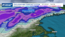
The answer for southern and coastal New England is no – as will be evidenced by a storm forecast to hit late this week, warmer air will still freely move north and rain is expected for many. In the mountains of northern and western New England, however, a substantial snowstorm is in the making centered on this upcoming Friday.
Get Boston local news, weather forecasts, lifestyle and entertainment stories to your inbox. Sign up for NBC Boston’s newsletters.
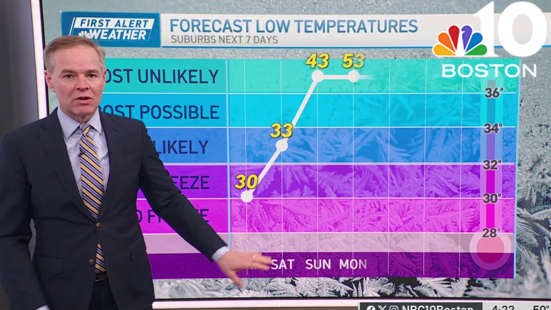
Until then, there’s no question winter air is here. Colder-than-normal air will hold daytime high temperatures in the 30s with a busy northerly wind Monday keeping wind chill values in the 20s at the warmest time of day. Overnight lows will be on either side of 20 with a slowly subsiding wind through Tuesday, then a fresh, cold breeze pushing wind chills back into the 20s Wednesday.
Although the weather will stay mostly dry in New England, a large and strong energetic disturbance dropping south overhead Tuesday night and Wednesday will likely prompt snow showers and squalls in Maine and the mountains of northern New England, and very well may trigger some snow showers across eastern New England as well.
That disturbance will leave a fresh shot of chill behind on Wednesday, which is when the wind kicks up again regionwide, just ahead of a much larger storm gathering strength in the nation’s midsection at midweek and arriving to New England by late week.
This larger storm will deliver widespread blizzard conditions to portions of the Northern Plains and Intermountain Region and heavy snow to much of the west, with accumulating snow as far south as northern Mexico, south of the Arizona and New Mexico border! This impressive storm will make travel nearly impossible in parts of Wyoming, Nebraska, North Dakota and Colorado. with zero visibility in snow and blowing snow, and a broad area of 18 to 24 inches across the Northern Tier of the U.S.
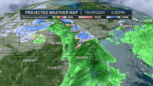
After some scattered showers develop Thursday, an initial burst of inland snow Thursday night can’t be ruled out as far south as central Massachusetts and south-central New Hampshire. However, a strengthening east wind should change most of southern and coastal New England to rain with 45 mph gusts Friday. Meanwhile, northern and western New England falls into the heavy snow zone, picking up one to two feet of snow if all goes as planned!
Though at least snow showers would linger into this weekend in the mountains, the rest of New England is likely to dry out after some possible Saturday morning showers depart. Then, mostly dry weather probably takes hold into early next week.
Weather
In the longer range – beyond the 10-day – I see two potential windows for storm development…that is, times where the jet stream opens the door a bit more to a possible storm of either snow or rain. One is centered either side of Dec. 22, and the other is centered either side of Dec. 26. It's far too early to know if these opportunities will come to fruition, but we’ll be keeping an eye out.
Be prepared for your day and week ahead. Sign up for our weather newsletter.
