
-
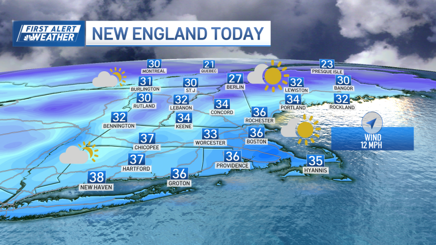
Cloudy and chilly Sunday evening in Boston
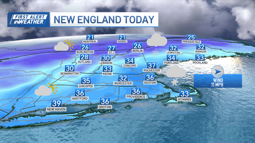
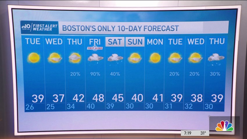
More clouds than sun will be with us this afternoon as low pressure tracks just north of the Canadian border today into tonight. Snow showers and flurries will develop across the higher terrain of northern and western New England with several inches of snow possible across the highest peaks. The rest of us may see a stray flurry or...
-
Cloudy and chilly Sunday evening in New England
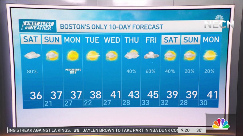
Today: Some AM sun, more afternoon clouds, stray flurry, gusty southwest wind. Highs 34-38. Overnight Tonight: Clear sky, breezy, and cold. Lows 22-27. Monday: Lots of sunshine, chilly. Highs 35-38.
-
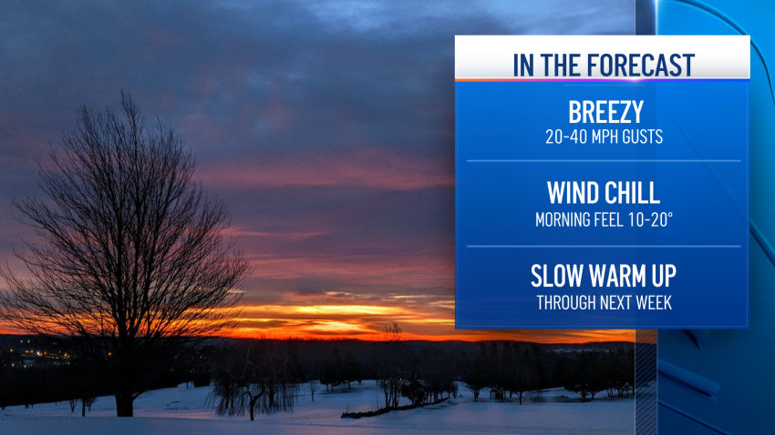
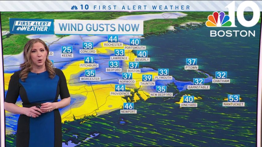
Chilly and breezy conditions to continue through Sunday in Boston
Cold and breezy conditions persisting through Sunday and into Monday morning. This morning, teens and low 20s for temperatures. When you factor in the wind gusts of 20-45 mph, and it’ll feel more like the single digits and teens. Coastal areas, especially on the Cape, will see the higher end of the range. While inland area wind gusts stay...
-
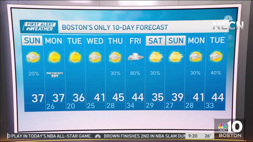
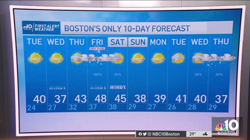
Forecast: Could Boston get more snow the rest of this blustery weekend?
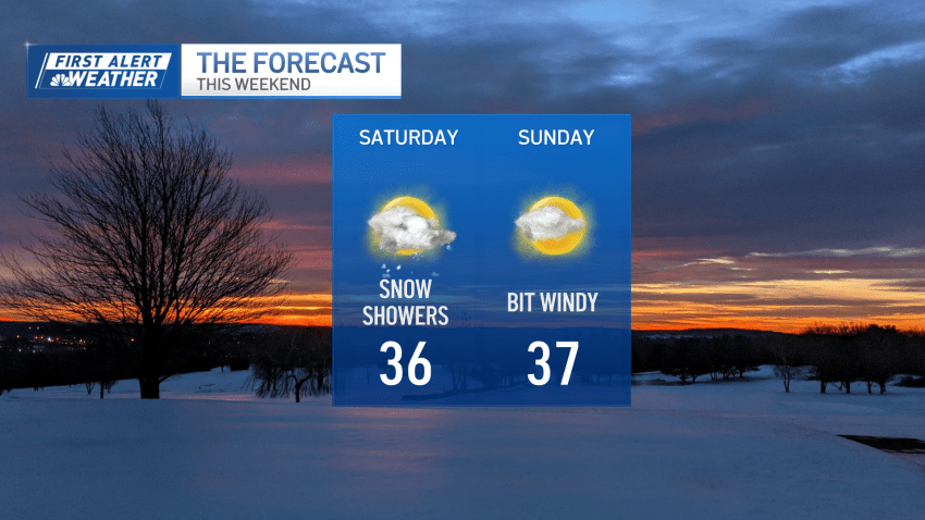
Overnight Saturday night: Few clouds early, clearing, breezy. Lows around 20. Sunday: Breezy with sun and clouds. Highs mid 30s.
-
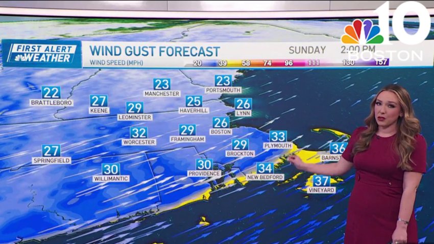
Chilly Saturday in Boston with light snow in the afternoon
Unsettled and seasonably chilly today with lots of clouds around as well as scattered flurries and snow showers. Highs reach the mid 30s south, upper 20s to low 30s north with an increasing northwest wind. A cold front slicing through the region this afternoon will help kick off a line of snow squalls which may produce briefly moderate to...
-
Snow squalls expected on Saturday in New England
Today: Mostly cloudy, scattered flurries and snow showers, late afternoon snow squall. Highs mid 30s. Overnight Tonight: Few clouds early, clearing, breezy. Lows around 20. Sunday: Breezy with sun and clouds. Highs mid 30s.
-
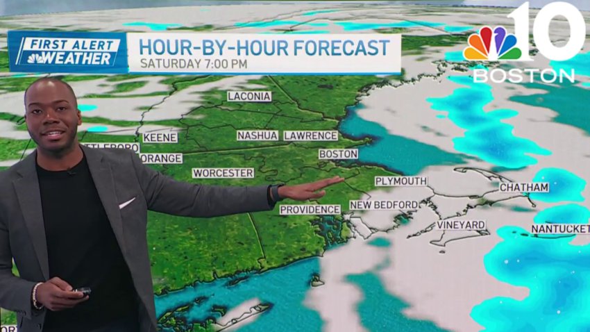
Cloudy Saturday with afternoon snow showers in New England
The wind has eased, for now. We’re watching the potential for some light snow with a quick-moving system to the south ands the possibility of snow squalls in the afternoon across the entire area. Temps will only rise into the mid-30s thanks to limited sun today. We’re not even worthy of the “partly sunny” designator for the sky today....
-
Mostly cloudy Saturday with some snow in New England
Today: Mostly cloudy, scattered flurries and snow showers, late afternoon snow squall. Highs mid 30s. Overnight Tonight: Few clouds early, clearing, breezy. Lows around 20. Sunday: Breezy with sun and clouds. Highs mid 30s.
-
Forecast: A bit more snow coming for Boston's holiday weekend
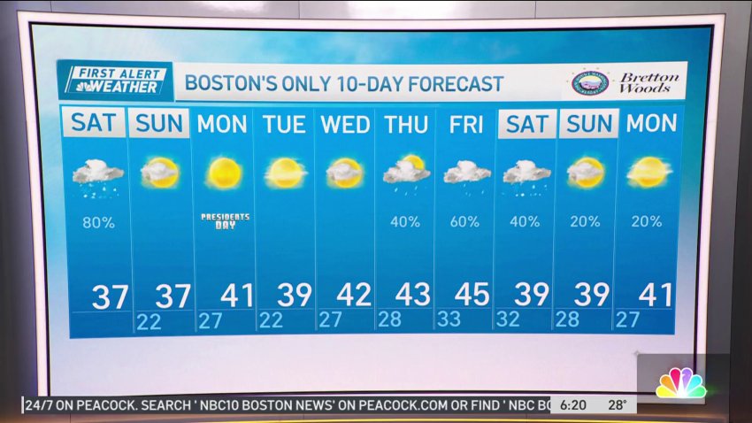
Friday evening: Blustery with partly cloudy skies. Temps in the 30s, wind chill 20s. Northwest gusts diminishing a bit. Overnight Friday night: Late light snow far south, otherwise cloudy. Lows in the 20s. Saturday: More clouds than sun with a few snow showers. Highs in the 30s. Sunday: Breezy and fair. Highs in the 30s.
-
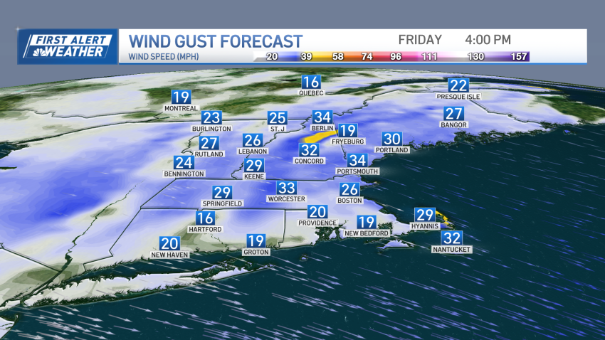
Cold and icy Friday night, with more snow showers on tap for the weekend
Snow showers continue throughout the day in scattered areas as a gusty northwest, west wind takes over. Meanwhile, the mountains continue to see snow showers through afternoon Friday, leading to additional 1 to 3 inches of snowfall on the peaks. As our wind cranks up through noon Friday, we could see some blowing/drifting snow north, with isolated areas of damage…
-
Forecast: Blustery day, cold and icy night ahead for Boston
Friday: Blustery with sun & clouds. Highs 35-40, wind chill 20s. Northwest gusts 40-50 mph. Overnight Friday night: Late light snow far south, otherwise cloudy. Lows in the 20s. Saturday: More clouds than sun with a few snow showers. Highs in the 30s. Sunday: Breezy and fair. Highs in the 30s.
-
Weather Forecast: Sunny, Cool Tuesday
Monday night: Clear, cold. Lows around 20. Tuesday: Sunny and cool. Highs near 40. Wednesday: Sunny, gusty wind. Highs in the upper 30s.
-
Weather Forecast: Clear and Cold Overnight
Monday evening: Mostly clear, cold breeze. Temperatures in the 30s, wind chill in the 20s. Monday night: Clear, cold. Lows around 20. Tuesday: Sunny and cool. Highs near 40. Wednesday: Sunny, gusty wind. Highs in the upper 30s.
-
Forecast: Staying Wintry Before Next Big Storm
Monday evening: Mostly clear, cold breeze. Temps in the 30s, wind chill in the 20s. Overnight Monday Night: Clear, cold. Lows around 20. Tuesday: Sunny and cool. Highs near 40. Wednesday: Sunny, gusty wind. Highs in the upper 30s.
-
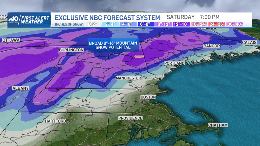
Parts of New England Could See Over a Foot of Snow Later This Week
Most of New England isn’t digging out, but we are brushing off! For some, it was a full-fledged dig, where over half a foot of snow fell in parts of western Massachusetts, with Berkshire County leading the snow tally with nine inches measured in Lenox. For others, a coating to two inches was more commonplace. While morning flurries depart...
Trending
