
No surprises Friday. It's soggy again as we watch the final round of rain move through with this seemingly endless wet spell.
Across the Worcester Hills and parts of southwest New Hampshire, a fingernail of cold has settled in. It's here that light icing may be creating some slick conditions. We're expecting a gradual rise above freezing later Friday as the precipitation winds down across all of southern New England.
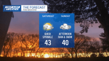
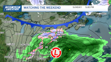
We'll pause the rain train over the weekend — although a sprinkle is still possible Saturday — as our attention focuses on an approaching storm Sunday. A few issues with this one, but at least we're confident in a track offshore.
Get Boston local news, weather forecasts, lifestyle and entertainment stories to your inbox. Sign up for NBC Boston’s newsletters.
There's cold around, but the deep chill will wait until late Sunday night to spill in. This will eventually change us all over to snow as the storm intensifies and moves east.

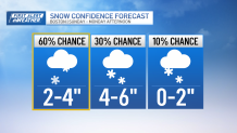
Right now, our greatest chance for serious accumulation (6 inches or so) is in the elevated terrain of central Massachusetts and cities and towns northwest of Interstate 495 into southern New Hampshire.
Along the coast, we'll start as rain then turn to snow at the end. Playing the odds, we find Greater Boston in the lower end of the snow range, with a 60% chance of 2 to 4 inches. Despite the lower numbers, we can still expect tricky travel into the morning commute on Monday as temperatures plummet and the wind picks up.
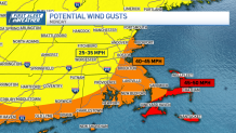
Speaking of, gusts will crank in this storm, primarily at the coast. We could see speeds top 45 miles per hour on Cape Cod and the Islands throughout Monday.
Snow consistency will be wet and heavy this go-round, with it pasting to everything right to the last flake.
Keep your eyes peeled for updates in the coming days. Stay with us online, on-air and on your favorite streaming platform.
