
We have enjoyed a beautiful day as we kicked off the work and back-to-school week. As expected, an onshore breeze kept us cooler at the coast vs. inland.
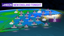
Clouds increase tonight and some scattered rain moves across western and northern New England as lows drop to the upper 30s and 40s north, mid 40s south. The rain holds off in Boston until later tomorrow.
Get Boston local news, weather forecasts, lifestyle and entertainment stories to your inbox. Sign up for NBC Boston’s newsletters.
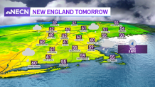
Grab your umbrella Tuesday morning
Tuesday brings us scattered rain showers as a cold front moves through. Northern New England will see the rain in the morning first, with showers in southern New England by afternoon. By evening a low pressure system develops south of New England and enhances our rain chance overnight into Wednesday morning.
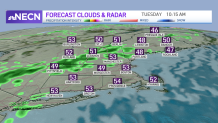
This low doesn’t completely move out so we continue to see a cool, showery weather pattern through midweek and perhaps into the end of the week. Snow showers are also possible across the mountains for Thursday into Friday. Highs stay in the 50s through the rest of the week thanks to the unsettled pattern. We finally shake this cool pattern for the weekend with slightly warmer temps by Sunday.
