
Well, it’s a chilly start to our weekend out there with widespread 30s and 40s stepping out the door this morning. We’ll make a decent rebound this afternoon, into the 60s regionwide, though it will still be breezy, with numerous gusts at 25-35 mph. Far northern and eastern Maine are the exception where gusts 45-55 mph may result in some scattered damage.

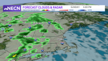
Tomorrow, morning sun will be followed by afternoon showers advancing in from west to the east late in the day. These showers will be scattered Sunday night through Monday as jet stream disturbances ripples through the sky aloft, dragging a surface cold front through later Monday or early Tuesday.
Get Boston local news, weather forecasts, lifestyle and entertainment stories to your inbox. Sign up for NBC Boston’s newsletters.
Meanwhile, Hurricane Fiona is racing toward Nova Scotia and Newfoundland, and is set to deliver considerable wind damage there. As the storm marches north into Atlantic Canada, its wind field will continue expanding, part of what’s driving the gusty conditions in New England, and enough to prompt gale warnings over our coastal waters and storm warnings for Eastern Maine.
Waves emanating from Fiona continue to build with breakers reaching 4 to 6 feet today and offshore waves as high as 10-20 feet outside of George’s Bank, not only posing a danger for New England fishing fleets offshore, but also driving powerful surf into New England’s beaches with strong rip currents and pockets of beach erosion. Meanwhile, over the Caribbean a strengthening storm will become Hurricane Hermine this weekend, taking aim at Florida by the middle of next week. While a persistent pattern of frequent disturbances and associated cold fronts should ensure Hermine stays south of New England at the end of next week, the only thing we’ll need to watch carefully is if a disturbance at midweek – currently predicted to deliver passing showers here on Wednesday – strengthens enough to change the steering flow over the East Coast to point more south to north. At this point, that’s not likely, but it’s also not entirely impossible so our First Alert Team will watch the forecast carefully in the coming days.
