
Thunderstorms continue to roll through New England, mainly southern New England this evening as a cold front moves through. This will bring us a dramatic cool down for the rest of our 10-day forecast and highs in the 70s in Boston by tomorrow.
Severe thunderstorm warnings have been issued in Massachusetts but have since expired. See the latest severe weather alerts here.
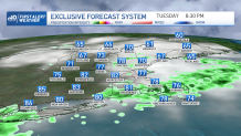
More strong to severe storms are possible, especially if they interact with a backdoor front sitting along southeastern Massachusetts. This change in wind direction will briefly rotate an updraft, creating the potential for brief rotation, but it will primarily allow a storm to sustain itself to produce a downburst of rain and wind, perhaps hail. Unless a storm moves over that area, we are looking at different threats and more pulsing-type storms. Damaging wind, heavy rain and lightning are still the main threats from any storm today.
Get Boston local news, weather forecasts, lifestyle and entertainment stories to your inbox. Sign up for NBC Boston’s newsletters.
The storm threat shifts to more southeastern New England, and even south of Boston around 7 p.m. The severe or strong storm threat dies down after sunset and after we lose some instability from daytime heating. Leftover thunder and rain will slowly creep across the south coast, Cape and islands through midnight and then by tomorrow the front is out of here.
Cooler air and drier air will follow. Northern New England will have a noticeably cooler and crisper night with lows in the 50s, while southern New England holds onto the mugginess and lows in the 60s. Tomorrow morning we wake up to patchy fog and clouds. Then clouds and some spotty showers hang around the coast with an onshore wind. Temps will be in the 70s east, with some valleys west only in the 80s, so the big cool down finally takes over.
