
While a few showers are in the forecast this week, it’s only parts of Maine that are expected to receive a soaking, drought-denting rain. But even in the Pine Tree State, we’re unlikely to see much rain where it’s most needed, in southern parts of the state.
The weather pattern this week features a southward dip, or "trough," in the jet stream winds aloft over the Northeast, meaning somewhat cooler air is sagging south from Canada, as energetic jet stream disturbances gather overhead.
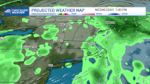
The gathering energy aloft will result in a storm – a sizeable one, at that – developing over the ocean to the south of New England, then tracking north to Nova Scotia before backing west toward New England. This path, however, puts the associated heaviest and steadiest swath of rain over the ocean first, then Nova Scotia to central, eastern and northern Maine Wednesday into Thursday, leaving the rest of New England with some occasional showers at times, but no opening for substantial moisture to produce much-needed soaking rain.
Get Boston local news, weather forecasts, lifestyle and entertainment stories to your inbox. Sign up for NBC Boston’s newsletters.
Instead, most of New England finds a transition from sun to clouds Monday, with a few of the building, puffy cumulus clouds growing enough for an isolated sprinkle.
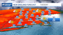
Tuesday likely starts with more limited sun and a 20% chance of light showers in addition to some sprinkles as the breeze increases from the northeast, gusting to 30 mph. While a northeast wind is off the ocean, and this does moisten the air a bit, conditions are so dry that simply the increase in wind is likely to boost brush fire danger for much of New England.
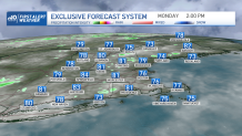
The busy wind comes on the far northwest periphery of the developing ocean storm, and that northeast breeze is expected to gust to 35 mph at times on Wednesday, as the storm makes its closest pass to southern New England. Although the greatest chance of showers is Wednesday, most of New England still sees little more than a 50% chance of showers before drier weather returns Thursday onward, keeping week-long rain totals around a tenth to a quarter inch.
That means we’ll fall deeper into drought over the next week. The rainy exception this week, as mentioned, will be central, eastern and northern Maine, where half an inch to an inch of rain is expected Wednesday into Thursday.
Weather Stories


The weekend brings fair sky and temperatures returning to the 80s for most of New England as a bubble of high pressure – fair weather – settles into the region, though the light wind associated with this fair weather cell means sea breezes are possible Thursday through Sunday.
Summer warmth continues next week in the exclusive First Alert 10-day, and while some showers may fall Monday or Tuesday, right now there’s no big rainmaker that stands out through the end of August.
