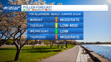
An area of low pressure is passing to our south today, bringing in clouds, cool temps, drizzle and periods of showers through Tuesday. This will help to lower our wildfire risk and lower our pollen count.
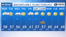
Highs today will be in the 50s as we see hit our miss shower chances. Keep that umbrella handy as you head out today or this evening. The onshore flow will keep temps in the 40s overnight with drizzle and fog.
The heaviest rain around Boston will be around midnight tonight, tapering off predawn Tuesday. Highs on Tuesday will still be in the 50s thanks to the onshore flow early. By late day we could see some breaks of sun west to east and if we do some temps will be milder.
Get updates on what's happening in Boston to your inbox. Sign up for our News Headlines newsletter.
Get Boston local news, weather forecasts, lifestyle and entertainment stories to your inbox. Sign up for NBC Boston’s newsletters.
Wednesday brings in more scattered rain and highs in the 40s and 50s with more of an onshore flow. Thursday is shaping up to be the best day of the week with spring warmth and highs in the 60s to low 70s. Friday we start to cloud up but temps increase to around 60 degrees.
This weekend is a tough forecast with a cutoff low nearby. The American model has this positioned over southern New England through Saturday, bringing a northeast wind and temps around 50 with rain. On the other hand, the Euro brings this low farther south and then we end up drier but still cool with an onshore flow.
We are going more optimistic for the weekend with showers Friday night into Saturday morning, then drying off late Saturday. We will still be cool and windy both days this weekend. Mother’s Day with highs in the mid 50s and mainly dry. A warmup looks to take over for next week. Stay tuned for weekend weather forecast updates.