
Our pre-Thanksgiving storm was slinging snow Tuesday night. Some spots picked up over an inch in central Massachusetts as the cold was reluctant to give up ground.
The tables have turned Wednesday morning as all spots are over to rain. We'll see it fall moderately at times this morning, then watch it ease to sprinkles and drizzle this afternoon.
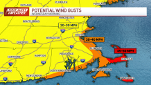
Winds will peak along the coast in the next couple of hours, with gusts to 40+ along the coast — and near 50 on the Cape and Islands. As the storm passes, the winds will briefly pause and then switch to the northwest in the afternoon.
Get Boston local news, weather forecasts, lifestyle and entertainment stories to your inbox. Sign up for NBC Boston’s newsletters.
We'll see the wind stick around Wednesday night and Thursday as well, but at much more tolerable speeds of 15 to 25 miles per hour.
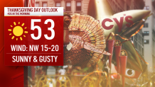
We have plenty of sun in store for Thanksgiving. Temperatures start in the 40s, then leap to the low 50s by afternoon. This will be the "warmest" day of the holiday weekend. Highs Saturday will be the coldest, with many spots staying in the 30s during the afternoon.
Weather Stories


The pattern relaxes for the next several days. There is a small storm system that could toss some rain or snow our way early on Monday, but next week remains quiet and cold.
Be safe and enjoy your Thanksgiving!
