New England is gearing up for a little snow Monday night, then possibly a big storm for Saturday that has prompted a First Alert stamp on our 10-day forecast.
Smaller Snow Chances Early in the Week
WATCH ANYTIME FOR FREE
Stream NBC10 Boston news for free, 24/7, wherever you are. |
A clipper system is heading our way for tonight and Tuesday morning. This is a quick-moving system, that generally brings in a couple inches of snow, carried from the origins of Alberta Canada.
Get updates on what's happening in Boston to your inbox. Sign up for our News Headlines newsletter.
The most snow accumulation is mainly staying in the northern half of New England, and it’s more snow due to the fact that our snow ratios are more like 20:1 (10:1 is normal) and flurry consistency. Some mixing is possible along the south coast for Tuesday morning as temperatures hover around 32 degrees.
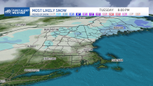
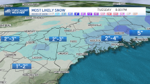
A coating to 1" of snow is likely for Boston, 1-2" in the Worcester Hills & Berkshires, 2-3" in the mountains, with some of the peaks getting over 3" of snow. A heavier snow is forecast to move across northern New England, approximately over interior Maine, so 2"-5" of snow is possible there.
Weather Stories
Colder air returns for Tuesday night as temps drop to the single digits again, and highs stay in the teens for Wednesday. We stay sunny and quiet for midweek before a large storm system affects us as the weekend nears.
Nor'easter Possible This Weekend
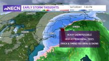
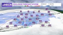
We have the potential for a major nor’easter sometime Friday night into Saturday. The track and timing are still to be determined, with still a low chance it could miss us. However, some key indicators hint that we will see at least something between Friday night through Saturday night. In fact, our exclusive NBC forecast model has a high POP for the eastern half of New England on Saturday. Several inches of snow is possible in Boston and across eastern New England. If the storm tracks in the right way, we won’t just have over half a foot to a foot of snow, but also damaging winds and coastal flooding.
Our First Alert weather team will continue to update on this storm potential.

