
We woke up to bitterly cold wind chills again across New England this morning.
It felt like the 20s and low 30s as the gusty northwest wind continued throughout the night. A cutoff low pressure system continues to spin around eastern Canada and now it slowly pulls away as we head into the weekend.
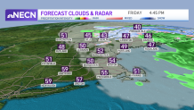
On Friday, expect off and on clouds mainly in eastern New England versus sunshine in western New England. Highs only reach the 40s in Maine and the 50s elsewhere thanks to the cool airflow from Canada. The wind remains gusty, too, from the northwest at around 30 mph.
Get Boston local news, weather forecasts, lifestyle and entertainment stories to your inbox. Sign up for NBC Boston’s newsletters.
Our brush fire danger remains high due to the dry brush, dry air, and gusty winds. Our pollen count is also very high again with the dry weather (for most) and gusty winds.
Snow showers slowly wrap up across the crown of Maine tonight. Drier air heads in, but the clouds hang tight in Maine tonight into Saturday. Lows drop into the 30s again, but the wind chill won’t be as bad as the wind subsides a bit.
The low pressure system slowly pulls away Saturday, but we still have temps in the 50s and partly cloudy skies. Sunday is the better day of the two this weekend with highs in the mid 60s and sunshine for all.
Weather Stories


Milder temperatures stick around for next week with highs in the 60s, but each day there is a chance for rain as little waves of low pressure pass through from time to time.
There could be a run at 70 degrees by Tuesday inland; however, if the track and timing of a low pressure wave is during the day (instead of overnight Monday and another Wednesday like what we see now), the clouds and showers may prevent that warmup. Stay tuned for updates!
