After an incredible late spring and early summer stretch of weather, days like today have become harder to come by in July. Sunshine and temperatures well into the 80s, even pushing 90° is forecast.
A flow of air thousands of feet above our heads, driven by the jet stream steering winds aloft, is blowing from western Canada to the Great Lakes and New England. The air is carrying three features that will impact our forecast: energetic disturbances, cooler air and wildfire smoke.
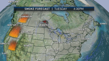
The wildfire smoke is the first and most apparent impact on New England’s sky Tuesday. Carried east from wildfires in the western U.S. and western Canada, thousands of feet aloft, the smoke will both add a haze to the Tuesday sky and provide some extra color to the sunset Tuesday.

Get Boston local news, weather forecasts, lifestyle and entertainment stories to your inbox. Sign up for NBC Boston’s newsletters.
The energetic disturbances caught in the flow of west and northwest wind aloft are set to arrive to New England Tuesday afternoon. This raises the risk of showers and thunderstorms – some possibly strong - in northern and western New England.
Although southern and eastern New England are far less likely to find Tuesday afternoon storms, an isolated shower can’t be ruled out in eastern Massachusetts Tuesday afternoon. Then the storms of northern and western areas may carry south and east while slowly weakening late Tuesday evening and overnight Tuesday night.
Aside from the isolated showers, mariners will find a delightful Tuesday on the water with a nearly calm sea and very light wind.

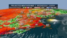
Changing weather Wednesday will be marked by a slow-moving cold front. That front will deliver occasional showers to northern New England over much of the day. Southern New England will see downpours and thunder through the afternoon and evening, where damaging wind gusts and localized flash flooding will be possible given the expected strength of the storms.
Weather Stories
New air streams into New England by Thursday, lowering humidity dramatically and bringing fair and delightful weather. One quick-moving disturbance raises the chance of a passing shower slightly Friday before another shot of comfortable air with a fair sky to make Saturday the pick of the weekend.
The unfortunate by-product of cool and comfortable air is, eventually, warmth and humidity returns this time of the year and when that happens, a collision of air means an increased chance of clouds, showers and rain.
Right now, it looks like that transition from nice weather to showers happens from Saturday (nice) to Sunday (cloudy, showery). The chance of showers remains elevated into early next week but the weather pattern may start to move a little faster, with a day or so of spacing between shower chances by the way it looks right now in our exclusive First Alert 10-day forecast.


